


Boeotia
Physical Description
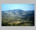
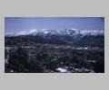
Boeotia is in Central Greece. The region is a large and fertile plain, surrounding the great Copais Lake, now drained. Boeotia lies between the Euboean Straits and the Gulf of Corinth, and is bounded on the north by Opuntian Locris, on the south by Attica and Megaris, and is shut in by the chains of Mts. Helikon, Kithairon, Parnassus, and Ptous. Mount Helikon, which rises to 1739 m, is the highest point in Boeotia. Numerous rivers, of which the Kephissus was the most important, descend from the mountains and feed Lake Copais. The rolling plain of Boeotia is one of the nost productive agricultural regions of Greece. In antiquity Boeotia was renowned for its grainfields and excellent cattle (the root meaning of the word Boeotia). The southern land is rough and mountainous with good harbors on the Corinthian Gulf which, unfortunately, are not easily accessible; the north is made up of hill country with a narrow seaboard, and to the east lies rolling country watered by the Asopus river. The extensive and fertile plains of Boeotia are torrid in the summer and raw in the winter. Boeotia's plain is divided into two parts by Mount Helikon. The rich northern plain, of which Orchomenos is the center, contains Lake Copais. In the bed of the lake there are natural caverns or "swallow-holes" in the limestone, and when these are kept clear, the waters of the lake are drained. The southern plain is traversed by the Asopus river which passes through Attica to enter the sea near Oropus. Of the many cities in Boeotia, Tri-odos is known for being the first meeting place in antiquity of three roads from Daulis, Delphi and Ambrossos.History
Boeotia was famous in antiquity for cereals, horses, cattle, and sheep. It was not a maritime state, although it possessed a coast and harbors on the Strait of Euboea and on the Corinthian Gulf. Boeotia had a flourishing existence in prehistoric times with the Mycenaean centers at Orchomenos, Gla and Thebes. The region was settled early by the first wave of Greek speakers. As a result there were two dialects spoken side by side in the classical era, Ionic and a Northwest Greek dialect. Generally the importance of Boeotia in Greek history varied depending on the degree of Theban control. It was the birthplace of Hesiod, Pindar and Plutarch.Sites
Levadhia, the modern capital of Boeotia, is situated on the southwestern edge of the fertile Copais plain. In ancient times it was famed for housing the oracle of Trophonios. Thebes, on the other hand, situated on the south edge of the east plain of Boeotia, was the capital of the district in antiquity, having replaced Orchomenos as the leading city. The site of Thebes was occupied in the Early Helladic period (second half of the third millennium B.C.) and was a major Mycenaean stronghold. Sometime after the Trojan war, Thebes defeated Orchomenos to become the capital of a loose federation called the Boeotian League. This federation of the greater cities of Boeotia was governed, in the fifth century, by eleven magistrates, two from Thebes and one each from the other cities. Historically Thebes was an opponent of Athens, but the two cities finally joined forces against Philip II of Macedon. Despite their cooperation, they were defeated. Orchomenos, which stood on a promontory on the north of the Copaic plain, was the capital of a Minyan principality which belonged to the Mycenaean cultural sphere. Earlier in history the site had been occupied by a Neolithic people. Although Orchomenos had been a powerful city in Boeotia, by the seventh century B.C. it was overshadowed and finally conquered by Thebes. Gla is the site of a stupendous Mycenaean fortress. Gla lies at the northeastern end of the Copais plain, and is encircled by massive walls 5.70 m thick and 3 km long. These walls gained Gla the title of the largest stronghold of its period. Chaironeia, located in the Kephissus valley, was the northernmost town of Boeotia. In the fifth century B.C. it was subject to Orchomenos. Chaironeia owes its fame to its geographical position (on the route from northern to southern Greece), and to the monumental Lion of Chaironeia erected by Philip II of Macedon to commemorate his defeat of the Athenians and Thebans in 338 B.C. Chaironeia was also the birthplace of the philosopher and biographer, Plutarch (c. A.D. 45-120). Although Aulis was not an important Boeotian town politically, it is famous as the place where Agamemmnon sacrificed his daughter Iphigeneia before the start of the Trojan war. Aulis is located in northeastern Boeotia across from Eretria in Euboea. A Temple to Artemis was built at Aulis in the fifth century B.C. This long narrow temple had a porch, and 2 columns in antis, and was rebuilt with 4 columns in Hellenistic times. In Roman times, the entire temple was restored for a second time. Plataea lies on the northern slopes of Mount Kithairon, and was on the ancient road which ran from Thebes to Athens. Plataea is located about 1.6 km from Thebes. This town was the scene of the last battle on Greek soil during the Persian wars. The victory here ended the Persian threat to Greece. On the same ancient route from Athens to Thebes is the battlefield of Leuktra where the Spartans were defeated in 371 B.C. A survey by members of the British School in the hills west of Thebes begun in 1979 has discovered the probable site of the town of Askra, home of the Iron Age poet Hesiod. Curtis Runnels- boundaries of: Paus. 1.38.8, Paus. 9.1.1, Paus. 10.4.2
- most cities of Boeotia named after women: Paus. 9.1.1
- Phoenician immigration: Hdt. 2.49, Hdt. 5.57
- war with Athens: Hdt. 5.74-81
- alliance with Aegina: Hdt. 5.89
- "sacred road" through Boeotia: Hdt. 6.34
- strife of Athens and Boeotia: Hdt. 6.108
- submission to Xerxes: Hdt. 7.132
- Boeotians at Thermopylae: Hdt. 7.202, Hdt. 7.233
- nearly all Boeotia on Persian side: Hdt. 8.34, Hdt. 8.66
- Mardonius established in Boeotia: Hdt. 9.15, Hdt. 9.17, Hdt. 9.19
- Boeotians in his army: Hdt. 9.31, Hdt. 9.46
- their courage: Hdt. 9.67
- ruled by Athamas: Apollod. 1.8.6
- Ocaleae in: Apollod. 2.4.11
- Rhadamanthys in: Apollod. 3.1.2
- Cadmus traverses: Apollod. 3.4.1
- Eleutherae in: Apollod. 3.5.5
- easiest pass from B. into Phocis: Paus. 10.4.2
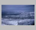 view from Mount Kithairon across east Boeotia in snow |
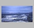 view across east Boeotia to Euboea |
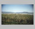 prehistoric mound from southeast |
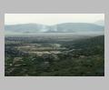 Copaic Basin from northeast, Gla in distance |
 Mount Helikon from Osios Loukas |
 snow-capped Mount Kithairon from southeast |
 meeting of the three roads where Oedipus slew Laius |