(q. v.), who was a member of Congress from 1877 to 1899, and speaker of the
in the Fifty-first, Fifty-fourth, and Fifty-fifth Congresses, contributes the following authoritative description of the plan of the proposed canal and criticism of the same:
Ever since the time when the bewildered successors of
Columbus failed to find the transit to the
East, by which they meant to pass by the land they had discovered to reach the far countries of the Orient they originally sought, the isthmus which connects the northern and southern continents of the
Western Hemisphere and separates the
Atlantic from the
Pacific Ocean has been the subject of the deepest interest, and the scene of a wonderful amount of research, considering the difficulties of topography and climate.
At first, all were reluctant to surrender the old idea, which had hardened itself into a tradition, with imaginary maps and charts, that, somewhere in the lagoons and tropical forests, was a passage-way already made by nature, which was only waiting the sails of the bold man who should discover or rediscover the highway of nations through which the commerce of two worlds would enrich and satisfy both.
It was soon found, however, that there was no passage made by nature; and Philip II.
felt assured that the
Lord did not intend the connection to be made between the two oceans.
While we have since learned that the intentions of the Deity are not to be lightly assumed, there was certainly in that age a fair chance for argument; for a more closely connected and determined union of hills and peaks can hardly anywhere be found, than in the range which runs from one end to the other of the isthmus, and its immediate connections.
Providence certainly did not intend that any world, any less rich than our own, should undertake the work of lifting great ships across the divide which separates the oceans.
All the probable passage-ways have
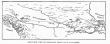 |
|
Bird's-eye view of Nicaragua Canal as it is planned. |
[
460]
been so far examined, that the world has settled down upon the belief that only two routes can be the scene of the great commerce which is hoped for in the future.
One is on the
Isthmus of Panama, which is the least in actual distance from the
Atlantic to the
Pacific, and the other takes its course through the peninsula which
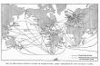 |
|
Map of the world showing change in trade routes after completion of the Nicargua Canal. |
connects the isthmus with the main continent to the north, as it goes widening from
Costa Rica to
Mexico.
One route is 46 miles, and the other between 170 and 180.
While there is that great difference in distance to be traversed, the difference in the canals to be excavated is by no means so great.
The
Panama Canal is all excavation from one end to the other, except 11 1/2 miles of artificial lake, and is 46 miles in length.
The
Nicaragua route makes use of Lake Nicaragua, an inland sea which was one day connected with the
Pacific and was a part of its vast expanse.
The landlocked sharks of the lake are living testimonials of the fact.
Besides the lake, a long stretch of river can be so utilized that, while the distance on the
Nicaragua route is what has been stated, the canal-making will be somewhere between 27 and 35 miles, according to the plan which shall finally be adopted.
In addition to the canal-making, the rivers used will have to be dredged and lowered and some parts of them turned aside.
The lake will also need dredging in various places.
Perhaps a brief description of the plan of the Maritime Canal Company, and a statement of the points of criticism, would enable us more easily to get a general idea of the state of the enterprise and the conditions of the various plans, so far as they have been indicated.
In the first place, it must be borne in mind that the main avenue of transportation is Lake Nicaragua, at 110 feet above the level of the sea. Of course, the waterline of the lake varies, nobody knows quite how much, but between limits of 12 or 14 feet between 112 feet and 98 feet. This variation, however, does not cover each year but a number of years, and is the extreme variation.
The level of 110 feet named in the Menocal plan, or 112 in the Ludlow suggestion, must be maintained all the time; for, while the top of the lake may be lowered from time to time, the bottom cannot be, and the difference between the top and the bottom is where the vessel runs.
This level of the lake, at 110 or 112 feet, is the height to which ships must be lifted to cross the altitude between the two oceans.
To this
[
461]
height the ships must be lifted on both sides by locks, and lowered on both sides by the same means.
The 110-feet level exists, naturally, only on the lake itself when it is high, and in the upper
San Juan, its outflow.
This would be only 56 miles of the 170, to which should be added a part of the
San Juan River on the eastern side.
To increase this distance, whatever it might be, so as to make the level extend for more than 140 miles,
Mr. Menocal conceived a plan which was singularly bold and attractive.
On the
Pacific side, he planned to have the first 9 miles from the lake end in a basin of 5 1/2 miles in length, and a mile in width, created by a tall dam called the
La Flor Dam.
This would add 14 1/2 miles to the navigation on the 110-feet level.
On the
Atlantic side, he proposed a dam at
Ochoa on the
San Juan 64 miles from its source, which is the lake, which would have extended the navigation on the lake level 64 miles more.
The dam was to be, or, rather, would have to be, 110 feet high, to which must be added the depth necessary to reach rock bottom, though
Menocal contemplated surface dam. At
Ochoa, the route was to branch off into the
valley of the San Francisco, where, by a dam at the end and by embankments on the sides, another basin was to be created, carrying the lake level 7 miles farther.
Adding all these extensions to the 56 miles by which the lake is crossed, it is found that, from La Flor Dam to the end of the
San Francisco Basin, there was to be a stretch of 142 miles on the same level, the level of the lake, not a natural varying level, but a permanent one to be created.
This 142 miles being taken out, there were left 26 or 27 miles of canal to be made.
Of the 27 miles, 11 1/2 were to be on the
Pacific side and the rest on the side of
Greytown.
These figures are not exact, but are sufficiently so for the present purpose.
On this plan, a ship from the
Pacific, at about half a mile from Brito, was to be lifted by one lock 21 or 29 feet, according to the stage of the tide.
Going on this new level 2 miles, the ship would be lifted by two locks which were to adjoin each other 45 1/2 feet by each, and about 90 feet by both, to the
Tola Basin, to begin its voyage of 142 miles through Lake Nicaragua and on the
San Juan River, down by the
Ochoa Dam to and through the
San Francisco Basin; then 13 miles through the
Eastern Divide, a rock cutting 140 feet in depth, to the
Descado Basin; at the end of which the ship was to be lowered 45 feet by a lock, travel 3 miles farther, and then, being lowered 30 feet, go on another mile, drop 31 feet and then, after 19 miles of canal, reach the harbor of
Greytown, which was to be made available by whatever expenditure might be necessary.
It will be seen, even from this inadequate description, that it was not an exaggeration to call this plan both bold and attractive.
It was attractive, because it gave a long reach of 142 miles, and in many ways seemed to lessen the amount of canal-making and the amount of dredging in the
San Juan River.
It was bold, because the dams and retaining embankments were, perhaps, without precedent in magnitude of work and in risk of disaster.
The dam at La Flor on the
Pacific side, and the dam and embankments at
Ochoa, together with the embankments of the
San Francisco Basin, were well calculated, to use the language of
Admiral Walker, “to keep its superintendent awake nights.”
Especially would this be so on
Mr. Menocal's plan, which did not propose to go down to rock formation, but to have “a dam of loose rock,” which,
Admiral Walker says, “would have to be enormous in size; it would be like moving a hill into the river.”
Of course, as was afterwards discovered, by going 80 feet below the bottom of the river, a dam could be built 190 feet in full height at a cost as yet unestimated.
As for the
San Francisco embankment line,
General Hains regards it “as the most dangerous matter in connection with the whole project.”
General Abbott, who, however, represents a rival project, says that “enormous embankments are required in the
San Francisco basins.
They are sixty-seven in number, and 6 miles in length, and some of them will rise from 60 to 85 feet above soft mud, which must be excavated to a depth of 30 feet to reach a clay foundation.”
Professor Haupt, a member of the
Walker board, says that there are some 8 miles instead of 6 of artificial work along the entire length of the line of the
San Francisco Basin.
The canal board, at the head of which
[
462]
was
Gen. William Ludlow, expressed grave doubts, similar to those expressed by the
Walker board, as to the risk and possible trouble that would arise under the Menocal plan.
After the canal board, which had neither the time nor the money to make an examination such as was needed, but which certainly brought back most valuable results showing great labor and skill, had made its report, a new board was appointed, consisting of
Admiral Walker,
Gen. Peter C. Hains, and
Prof. Lewis M. Haupt.
This board devoted much time to the investigation of the various engineering phases of the work.
General Hains expressed the impression that he would prefer to construct a lock and dam at Machuca Rapids, about 20 miles above
Ochoa, and lock down 25 or 30 feet so as to reduce the height of the
San Francisco embankments.
This would reduce the average height of the
San Francisco Basin embankments about 50 per cent., and of the
Ochoa Dam about 30 per cent. There is one disadvantage about this plan which
General Hains states, which is, that the level at which you leave the
San Juan is the level you must maintain across what is called the
Eastern Divide, and you must go just so much deeper in your excavation, which would add 25 or 30 feet to the 140 already planned for, making it 165 to 170 feet deep instead of 140.
This would be an extra expense, but not at all comparable to risk avoided.
The
Tola Dam and Basin are also subjects of destructive criticism on the part of both the later boards.
General Hains would do away with both and confine the work to a simple canal which, he thinks, presents no difficulties.
Professor Haupt seems rather to be in favor of lowering the dam, which would eliminate the basin.
It should be added that various other routes, after leaving
Ochoa, are to be considered in the light of these facts and such further investigations as may be found necessary.
It may be that, instead of leaving the
San Juan at
Ochoa, it could be left at Tambour
Grande, 10 or 12 miles lower, thus saving all the
San Francisco embankment.
One other difficulty has got to be met, and undoubtedly will be. The level of Lake Nicaragua must be maintained at 110 or 112 feet, or at some level at all seasons within very narrow limits.
That level is the basis of the whole work.
Between that level and the bottom of the canal must be space enough for the ship to move at reasonable speed.
The lower the top, the lower must be the bottom.
If the bottom must be lowered there must be more excavation and more cost.
Flood waters must be discharged, evaporation at the rate of 16,000 cubic feet per second in the dry season must be provided for. This.
is more than the whole discharge of the
San Juan.
The solution of this problem will help to fix the bottom of the canal, and that will help very materially to fix the price.
The cost of building the canal has been variously estimated.
Mr. Menocal made a detailed estimate of $65,000,000. The canal board of 1896 thought it would cost $133,000,000, but, in the testimony of the members before the committee of the
House, it was evident that they regarded $150,000,000 as the really safe limit which the constructor should have in view.
The report of the canal board announcing the estimate of $133,000,000 was subjected to some criticism by the Maritime Canal Company, the party then in interest, which was advocating a bill which contained the project of
Menocal with a loan from the government of the
United States.
How thoroughly that criticism was met can be seen in the testimony before the House committee, where the canal board, and especially its chairman, then
Colonel, afterwards General,
Ludlow, showed a complete mastery of the subject, so far as the short time and the small amount of money at their disposal would permit.
It is only fair, however, to say that a considerable portion of increased estimate arose from the fact that the canal board felt that the exigencies of the case demanded a more commodious canal than the company contemplated.
Congress then placed the matter in the hands of a new board, already mentioned, of which
Admiral Walker was the head.
Speaking of the probable cost, as
Admiral Walker put it: “We have made no figures.
It is no use to figure until we have all our data.”
“Speaking as anybody on the street might speak,” he put it at $125,000,000, “and would not be
[
463]
surprised if it came considerably below that.”
Professor Haupt thought the canal could be constructed for $90,000,000, while
General Hains, an army engineer, said: “I would not like to make a guess now and guaranteee that I would be within twenty-five or thirty millions,” but with that margin “of a possible reduction of $25,000,000 or $30,000,000,” he stated the maximum sum at $140,000,000. Of course such estimates are not to be depended upon.
When, in fact, it is considered that the
Suez Canal was estimated at $40,000,000, and constructed but with reduced dimensions of 72 instead of 125-feet bottom width for $110,000,000; that the
Manchester Canal, executed, not in the tropics, but in
England, was estimated at $50,000,000 for all expenses of all kinds, and cost more than $75,000,000, we can be sure that the element of uncertainty as to cost will be quite likely to be great.
There is so strong a desire on the part of some of our people to build this canal, that there is much intolerance of obstacles, whether they be real or imaginary.
Engineers are liable to be influenced unconsciously by this feeling.
It was only when they were attacked, that one board regretted that they had not said $150,000,000 where they had said $134,000,000; members of another board gave large sums, but added the possibilities of large reductions.
The influence of the wishes of ourselves and others never will cease to affect estimates of costs, but it never affects actual expense.
While the testimony given by the members of the
Walker board was, in a certain sense, premature, and no one appreciated that more than the members themselves, it was certainly very useful, for it showed that the canal board had made the very objections which the maturer subsequent examination sustained.
Much has been said about the feasibility of the canal, and it would be well to understand what that term means.
When the canal has been pronounced “feasible” it simply means that with time and money it can be built.
Whether it should be built, when, and how, and by whom, are the questions which depend upon other considerations as well as upon cost, though that is an important element.
The
Clayton-
Bulwer treaty, it is claimed.
gives to
England at least the right to demand the same privileges we have.
If so, we cannot use the canal, as suggested by
Mr. Hepburn, to subsidize indirectly our merchant marine by giving them lower tolls or making the canal free to them alone.
In time of war, a blown — up dam or embankment might shut up a war vessel.
In time of peace, however, there would be but small chance of damage.
As to the possible tonnage which would pass through, the subject has not been studied by any persons who were at once competent and unprejudiced.
The estimates, or, rather, prognostications, run from 300,000 tons to 5,300,000 tons, certainly a great discrepancy.
It would seem, therefore, that after the question of cost is determined, or perhaps while it is being determined, a commission of competent persons unprejudiced should be invited to study this part of the subject, and we shall be then equipped with the necessary facts to enable us to judge of the commercial success of the undertaking.
In this connection we must reckon with the
Panama Canal, which seems to be two-thirds excavated, and, taking into account the whole “installation” or plant, for want of a better word, to be one-half finished.
Vast sums of money have been spent there, and still more wasted or worse.
It is estimated that $100,000,000 additional will now push it from ocean to ocean.
Whether this is a sound estimate or not we do not know, for, unlike the
Nicaragua route, there have been no other investigations made than those by the company through its employes.
This matter will be investigated by our people, and we have a right to make all proper inquiries, because by the treaty of 1846 with
Grenada we guaranteed the neutrality of this canal.
The
Panama Canal was originally intended to be a sea-level canal, running on that one level without locks from ocean to ocean.
It is not needful for the present purpose to relate the history of its failures and of the disgrace and scandal connected with it. As a sea-level canal it was a failure, and no one now proposes to take up the enterprise in that form.
To some, perhaps to many,
Americans, it will be a surprise to know that, while the enterprise as a sea-level route has been given up, as a canal it has survived
[
464]
and is now in progress.
Whether it will be built or not no one can definitely say, but the experience of mankind is that where so much money has been spent more money has almost always gone, and such works are quite likely to get finished.
Were we able to free ourselves from ancient obligations and treaties, and make at
Nicaragua such a canal as our people really want, a canal which would be part of us like the
Sault St. Marie, other nations would have to finish the
Panama.
However that may be, it has seemed worth while, to enable us to give due consideration to the whole question, to state what the canal on the isthmus is to be, if the great enterprise is ever carried out. Perhaps that can be best done by taking a ship over the route, as we have over that in which we have been specially interesting ourselves.
We have to build our harbors, one at Brito on the
Pacific and the other at
Greytown on the
Caribbean Sea.
The other canal has two harbors made by nature:
Panama on the
Pacific and
Colon on the
Atlantic.
These harbors are already connected by a railroad built long ago, while on the other route a doubletrack railroad will have to be built at once from the lake to both oceans before any work can be done.
Transportation would otherwise be impossible in those almost uninhabited regions.
From the harbor of
Panama the ship is to go 7 1/2 miles on the sea-level to Miraflores, where she will be lifted by one lock 23 feet, more or less, depending on the state of the tide, which has a range of 20 feet at this end; then she will go 1 3/4 miles to
Pedro Miguel, where two locks are to lift the ship 55 1/2 feet to a new level 80 and 90 feet above the sea. The ship then moves 1 3/4 miles to Paradiso, where two locks are to lift her 55 feet more to the highest level, which is about 130 feet above the level of both oceans.
Thence, over this high level, she proceeds 6 1/4 miles to Obispo, where she begins to descend towards the
Atlantic.
At Obispo three locks lower her 65 1/2 feet, at which point she will reach the artificial lake to be made by damming the Chagres River, an artificial lake which covers an area of 21 square miles.
Through this lake the ship will journey 13 miles to Buhio, where two locks will lower her 65 1/2 feet to the canal, which thereafter will be again at sea-level, and 15 more miles at the sealevel will bring the ship to
Colon and to the
Atlantic Ocean. One more detail needs to be mentioned, for we shall want to know how the high level is maintained which constitutes 6 1/4 miles of the journey.
At Alhajuala, 10 miles northeast of Obispo, north of the canal-line, the upper
Chagres is to be dammed and a lake formed which will store 130,000,000 cubic yards of water.
A canal 10 miles long, beginning 190 1/2 feet above the sea, will conduct the water to the high level, which begins at Obispo and ends at Miraflores.
It will be over a rough country, but it is claimed to be “feasible.”
There are other plans which lower the high level in different degrees, but they cost more money or more time.
The level below the one described is, however, the one contemplated by the company.
That means fewer locks.
In both these great enterprises, time of completion is a most important element; for interest runs all night and, on such vast sums, breeds other vast sums of which people take little heed.
But while we lose sight of time it never loses sight of us, especially in the case of an interest account.
If it should be found that two canals are ready to be built by private capital, or even one, the neutrality of one being guaranteed by the
United States by the treaty of 1848, and both perhaps by the Clayton-
Bulwer treaty, then we shall have to consider what we want further.
If we want a canal built by the United States government under its own control, with power to fix discriminating rates in favor of its own citizens, with due fortifications for time of war, then we must consider our foreign relations.
It seems admitted by the friends of the
Nicaragua canal that these relations do not, as they stand now, admit such action on our part.
Hitherto. the treaty in one way has been refused amendment by
Great Britain, though thereto often requested.
Even from the cursory description here given, liable, of course, to contain some inaccuracies, it will be seen that the facts to be gathered to establish the best route demand the expenditure of both time and money, but an expenditure after all not
[
465]
out of proportion to the magnitude of the undertaking.
When you add to the picture the tropical growth and the climate, the wonder is that so much has been done.
It is, on the other hand, not a wonder that so much remains to be done.
There ought not to be any intolerance in regard to opinions on this great and important enterprise.
It is too difficult a problem to be mastered by enthusiasm alone.
Sound sense and discretion must also be called into action.
The final result no one can doubt.
The commerce of the world in due time will eliminate
Cape Horn to as complete a degree as it has eliminated the
Cape of Good Hope.
The uneasy dream of 400 years will soon be a waking reality, and, across the rockbound ridge which for all these years has defied the ingenuity of man, the great ships will go, freighted with the rich cargoes and the civilization of commerce and peace.
See
Clayton-Bulwer treaty; Morgan, John Tyler.


