


Euboea
Physical Description
Euboea, the second largest of the Aegean Islands, extends for some 180 km along the east coast of mainland Greece. The length and geomorphology of the island permits a natural division of Euboea into three distinct regions corresponding to its three major mountain groups. The north, dominated by the peak of Mount Pyxaria (1341 m), is heavily forested and has a climate and environment similar to the Pelion Peninsula on the mainland immediately to the north. The broadest and most fertile part of Euboea is the central region which contains relatively large plains south of Mount Dhirfis (1745 m), the highest peak on the island. Central Euboea lies closest to the mainland and is separated from it by only 40 m where the Euripos (Euboean Channel) narrows at Chalkis. The environment closely resembles those of Boeotia and Attica, with the exception that there is more rainfall on the eastern side of the island. The narrowest part of Euboea (in places less than 10 km) is the stretch of land between Dystos and Styra, which joins the central and southern portions of the island. Southern Euboea, with Mount Ochi (1394 m) at its center, is mountainous and sparsely inhabited. The region lies at a greater distance from the mainland and is subject to a maritime climatic influence. Southern Euboea is geophysically and environmentally distinct from the rest of the island and its climate corresponds with that of the northern Cycladic Islands.History
The natural division of Euboea has been paralleled throughout history by the socio-cultural divisions of the island. Each region is represented by a major town (Histiaia-Oreos in the north, Chalkis in the center, and Karystos in the south) which has preserved its importance from the first mention in the Homeric Catalogue of Ships down to modern times. This tripartite cultural division of the island is first reflected in the prehistoric settlement of the island by the semi-legendary tribes of the Ellopians in the north, the Abantes in the center, and the Dryopians in the south. In historical antiquity Chalkis and Eretria contested the fertile Lelantine Plain, located between the two cities and the commercial and colonizing role afforded by their locations at the center of the Euripos. Although leaders in the colonizing period of Greek history, the city states of Euboea later became politically subject to Athens and then to Macedonia.Sites
Histiaia-Oreos- Histiaia, overlooking the strategic north entrance to the Euripos and a large fertile plain, was described by Homer as "rich in vines." In 446 Athens conquered the city, expelled the inhabitants, and settled a colony of cleruchs at nearby Oreos. After the Peloponnesian War the Histiaians reclaimed their area and the city thereafter was known by either name. No systematic excavations. Artemision- A high promontory on the northwest coast, below which the first Greek-Persian sea battle occurred in 480 B.C. A Sanctuary of Artemis Proseoa on the cape was excavated by the German Institute in 1883. Chalkis- Located at the narrowest part of the Euripos (where the direction of the currents change as often as seven times a day), the city was a commercial center and sent out many early colonies. It was a trade and territorial rival to Eretria, which it fought for control of the fertile Lelantine Plain located between the two cities. Few ancient remains have been recorded, chiefly through salvage excavations. Eretria- Located on the Euripos ca. 20 km south of Chalkis, Eretria is first mentioned in the Homeric Catalogue of Ships and rivaled Chalkis in trade and the establishment of colonies abroad. Eretria's support of the Ionian revolt in 500 B.C. may have encouraged the later Persian invasion of Greece in 490 B.C. Excavations, sporadic since the 19th century, were assumed by the Swiss Archaeological Mission in 1964 and are the most extensive on Euboea. Lefkandi- A coastal settlement with associated cemeteries located halfway between Chalkis and Eretria. The site was first occupied in the Early Bronze Age (ca 3000 B.C.) and continued into the Geometric period (ca 700 B.C.) and is claimed as the old settlement of Eretria or Chalkis. Excavations were conducted by the British School in the 1960's. Dystos- A fortified city located on an isolated conical hill above a marshy plain ca. 30 km east of Eretria. The history of Dystos is little known, but it may have been an Eretrian deme. The well preserved Classical architecture was investigated briefly by the German Institute in 1895, but the site remains unexcavated. Styra- On the southwest coast ca. 30 km north of Karystos, Styra remained under the influence of Eretria during most of its history. No excavations. Geristos- The one safe harbor on the southwest coast and the first safe stopping point for ships returning from the east. A Sanctuary of Poseidon, first mentioned by Homer, is located at Geristos and an ancient road leads to Karystos, ca. 20 km to the northwest. There have been only test excavations. Karystos- Located on the north shore of a large bay, Karystos controlled the southern entrance to the Euripos and sea traffic moving through the Andros Straits. Karystos was the first Greek city to oppose the Persian advance in 490 B.C., but later fell under Athenian control and probably had an Athenian clerouchy imposed on its territory. In the Roman period Karystos was famous for its marble quarries. Only minor excavations in the region. Don Keller- (island) twice subjugated by Athenians: Paus. 5.23.4
- Athenian expedition into E. Paus. 1.36.4
- Athenian colony in E. Paus. 1.27.5
- Athenians slain in E. Paus. 1.29.11
- Myrtoan Sea begins at E. Paus. 8.14.12
- poor folk in E. wear pig-skins: Paus. 8.1.5
- Euboean antiquaries: Paus. 8.14.12
- battle of Euboeans with Thebans: Paus. 9.17.3, Paus. 9.19.3
- Euboeans routed by Hermes at Tanagra: Paus. 9.22.2
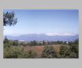 snow-capped Dirfis Mountains from west |
Euboea (2), daughter of Asterion
- nurse of Hera: Paus. 2.17.1, 2
Euboea (3), daughter of Thespius
- mother of Olympus by Herakles: Apollod. 2.7.7
Euboea (4)
- desirable object for Persian attack: Hdt. 5.31
- Chalcidians in Euboea defeated by Athenians: Hdt. 5.77
- Persians under Datis there: Hdt. 6.100
- Athenian ships off Euboea: Hdt. 7.189
- naval operations in Euboean waters: Hdt. 8.4-20
- Euboic coinage: Hdt. 3.89, Hdt. 3.95
- Euboeans in Sicily, their treatment by Gelon: Hdt. 7.156
- the Argonauts sail past: Apollod. 1.9.26
- Autolycus steals cattle from: Apollod. 2.6.1
- Cenaeum in: Apollod. 2.7.7
- wreck of the Greeks on the coast of: Apollod. E.6.4, Apollod. E.6.15