[
255]
Reminiscences of the Confederate engineer service
T. M. R. Talcott, Colonel Commanding Engineer Troops, Army of Northern Virginia, Confederate States Army
 | |
A “covered way” in Fort Pulaski, April, 1862--the garrison here made a continuous bomb-proof by leaning timbers against the inner wall of the Fort and then covering them with earth |
|
[
256]
[The text of this article is of especial value since it embraces personal reminiscences in a field where few official records or maps are available; namely, the operation of the engineer troops with the Army of Northern Virginia.
The chapter is broadened by illustrations showing engineering works of the Confederate army in the West and South.--the editors.]
The account of the services rendered to the Southern Confederacy by its engineers must be largely, if not wholly, from memory, owing to the loss of records pertaining to this branch of the
Confederate military service.
The following, therefore, must be considered merely a reminiscence of the
Civil War preserved in the memory of an individual participant in the events of the four years, from April, 1861, to April, 1865.
Prior to April, 1861, the
State of Virginia maintained the hope that wise counsels would prevail, and urged forbearance; but mindful of the old adage, “In time of peace prepare for war,” an appropriation was made for river, coast, and harbor defenses, and the services of a competent military engineer were secured to plan and superintend the work.
Thus it happened that, when the Ordinance of Secession was passed by the Constitutional convention of the
State of Virginia, on the 16th of April, 1861, in answer to
Lincoln's call for her quota of the seventy-five thousand troops, no time was lost in organizing a State corps of engineers to prepare defenses against the then inevitable invasion of the
State.
[
257]
Confederate engineers who made their mark.
When it is realized that few of the officers in the
Corps of Engineers March 16, 1861.
He Confederate Engineers Corps had any previous was made colonel the following year, and practice as military engineers, although some brigadier-general August 28, 1864.
He was of them had been educated at military academies, and that no engineer troops were provided for by the Confederate Congress until 1863, the work accomplished by the Confederate engineers seems all the more marvelous.
The Confederate coastwise defense were strengthened in a way that baffled the blockading fleet, and no two armies have ever been entrenched in the field as were the armies of the South and North before
Petersburg.
Walter H. Stevens became major in the
Confederate chief engineer of the Army of Northern Virginia before
Petersburg, and surrendered at Apponmattox.
Danville Leadbetter also became a major in the Engineer Corps March 16, 1861.
He was a brigadier-general of the Provisional Army of the
Confederate States February 27, 1861.
J. F. Gilmer was lieutenant-colonel of the Engineer Corps in 1861.
He became brigadier-general in the Confederate army in 1862, and major-general in 1863.
During most of his service he was chief of the engineer bureau.
[
258]
The moment that the
Norfolk Navy-Yard was evacuated, the erection and armament of batteries along the
Elizabeth River was begun to prevent its recapture; and thus
Virginia came into possession of a thoroughly equipped navy-yard, at which the
Merrimac, some time later, was converted into the ironclad
Virginia, and the guns needed for the speedy armament of batteries for the defense not only of the
Elizabeth,
James, and
York rivers, but also against attacks on
Norfolk and
Richmond by other lines of approach, were obtained.
Subsequently, the
Virginia Corps of Engineers was merged into that of the
Confederate States; and the cost of completing the defenses begun by the
State of Virginia was borne by the Confederate Government.
Very few of the officers in the
Confederate corps had any previous practice as military engineers, although some of them had been educated at military academies.
In this respect the
North had a decided advantage over its opponents.
No engineer troops were provided for by the Confederate Congress until 1863, when two regiments were authorized and organized, in time to take part in the campaigns of 1864.
Prior to that time, such duties as pertain to engineer troops were performed by details from divisions, generally known as Pioneer Corps, under the direction of officers of the Engineer Corps attached to such divisions.
Of the two regiments of engineer troops, the First Regiment and two companies of the Second Regiment were organized for service with the Army of Northern Virginia.
The other eight companies of the Second served elsewhere than in
Virginia, several of them in the Trans-Mississippi Department.
During the first three years of the war when pontoon bridges were needed, they were handled by the
Pioneer Corps, or other details from the ranks, under the direction of officers of the Engineer Corps.
The bridge on which
General Lee's army recrossed the
Potomac near
Williamsport after the battle of
[
259]
 |
|
An ingenious device of the Confederates in Pulaski
The Confederates had swung upwards the muzzle of this 8-inch smooth-bore sea-coast gun within Fort Pulaski, so that it could be used as a mortar for high-angle fire against the Federal batteries.
General Hunter and General Gillmore's troops, supported by the gunboats, had erected these on Jones Island and Tybee Island. Fort Pulaski, commanding the entrance to the Savannah River and covering the passage of blockade runners to and from Savannah, early became an important objective of the Federal forces at Hilton Head.
It was of the greatest importance that shells should be dropped into the Federal trenches, and this accounts for the position of the gun in the picture.
There was no freedom of recoil for the piece, and therefore it could not be fired with the “service” charge or full charge of powder.
Reduced charges, however, were sufficient, as the ranges to the opposing batteries were short.
With this and other ingenious devices the little garrison kept up its resistance against heavy odds.
It finally surrendered on April 11, 1862. |
[
260]
Gettysburg was an illustration of the corps' resourcefulness; for in this instance pontoon boats were lacking.
The expedition with which material was collected, boats built, and the bridge constructed was most creditable.
The pontoon bridges for the engineer troops in
Virginia were built at
Richmond under the direction of the engineering bureau, and were in accordance with the plans and specifications prescribed by
Captain (afterward General)
George B. McClellan, United States Corps of Engineers, in one of the engineering papers published some years prior to the
War between the States.
The pontoon bridge consisted of flat-bottomed boats, with longitudinal timbers to connect them, and planks for the flooring, all of which were lashed together with cords, so that they could be quickly assembled and as readily taken apart.
The transportation of them required wagons specially constructed for the purpose.
Provision had, of course, to be made to hold the boats in position against strong currents in streams to be crossed, by anchors or guy-lines to the shore.
When the campaign opened in 1864, the engineer troops attached to the Army of Northern Virginia, which was then at
Orange Court House, were used first as infantry to guard the depot of supplies at Guiney's Station, and afterward to support a cavalry Brigade which held the
Telegraph road, on the extreme right of
General Lee's position in
Spotsylvania County, where it crossed the
Ny, one of the four streams which form the
Mattapony River.
At this point earthworks were constructed, and the position was held until after the
battle of Spotsylvania Court House, when it was turned by the flank movement of
General Grant; and
General Lee retired to the line of the
North Anna River.
During
General Grant's demonstration against
Richmond, the engineer troops were used to strengthen the works which withstood his attacks at Cold Harbor; but anticipating the necessity at any time for a prompt movement across the
[
261]
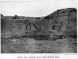
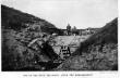
These two photographs of
Fort Pulaski at
Savannah, taken in April, 1862, after the bombardment by the
Federal batteries, show very clearly how the Confederate Engineers learned that the old-fashioned brick wall was of no use against modern guns.
The time had passed for brick and stone fortresses.
Granite was found to be weaker than sand.
Any yielding substance which would slow down and finally stop the great projectiles, and which could be shoveled back into position, no matter how much of it was displaced by a shell, proved far superior to any rigid substance.
The ruins of
Fort Pulaski taught the
Confederates how to defend Fort Sumterwhich was evacuated but never fell.
In
General Gillmore's Report on
Charleston he says: “One hundred and ten thousand six hundred and forty-three pounds of metal produced a breach in
Fort Pulaski which caused the surrender of that permanent and well constructed brick fortification, while one hundred and twenty-two thousand and thirty pounds of metal failed to open the bomb-proof of
Fort Wagner, a sand work extemporized for the war.... It must not be forgotten, in this connection, that in the former case the brick wall stood nearly vertical, and all the debris formed by the shots immediately fell into the ditch, and no longer afforded any protection to the wall left standing; while in the latter the mass was so formed that a large proportion of the sand displaced fell back and again within an area attempted to be breached.”
 | |
Fort Pulaski--the angle where the federals concentrated their fire |
|  | |
Inside the breached casemate (see above): rifled cannon vs. Bricks |
|
[
262]
James River, a pontoon bridge was laid at a point known as Chaffin's Bluff, and this was soon thereafter used to transfer reinforcements to the line between the
James and
Appomattox rivers, and to
Petersburg.
At the same time, one company of engineer troops was detachedd with a pontoon train and sent to
Petersburg, where a bridge was needed to facilitate crossing the
Appomattox River at that point.
Of the eleven companies of engineer troops which remained north of the
James during
General Grant's first operations against
Petersburg, one company was in charge of the pontoon bridge at Chaffin's Bluff and ten served as infantry on what was known as the
Deep Bottom line.
As soon as it became known to
General Beauregard that an attempt was being made to undermine a salient point on his line, he made use of the company of engineer troops then at
Petersburg, in an effort to protect the threatened point by countermining.
Two pits were sunk in the trenches, from the bottom of which drifts or tunnels were extended some distance beyond the entrenchments, and a circumvallating gallery was in progress, which, if it had been completed in time, might have discovered the exact location of the underground approach of the foe: although it was subsequently ascertained that while the drift by which the
Federals reached a point under the
Confederate lines was about half-way between the two Confederate workings, it was at a somewhat lower level.
However, the
Confederate works were incomplete when, on July 30, 1864, the
Federal mine was exploded.
The most lasting effect of this demonstration by
General Grant was to produce a feeling of impending danger at every salient point of the
Confederate line of defense; and
General Lee ordered eight more companies of engineer troops from north of the
James to
Petersburg, and made large details from the infantry to swell their numbers, in order to expedite the work of countermining, which, from that time on, was pushed energetically, until ample protection was afforded at all points
[
263]
 |
|
One of the guns that had to be dug out--Fort McAllister
Digging out the guns was an every-morning duty of the garrison in Fort McAllister, defending Savannah, during the three bombardments of the Federal monitors and gunboats--January 27, February 1, and March 3, 1863.
Every night the cannon in the Fort became buried with dirt thrown up by the Federal shells, yet every morning they were roaring defiance again at the attacking fleet.
No Federals set foot here until the little garrison of 230 men were confronted by Sherman's army of 100,000 and stormed on December 13, 1861. |
 |
|
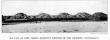
Fort Morgan, Mobile Bay, Alabama
Fort Morgan, on the right of the entrance to Mobile Bay, was one of the strongest of the old brick forts.
By August, 1864, it had been greatly strengthened by immense piles of sandbags, covering every portion of the exposed front toward the neck of the bay. The Fort was well equipped with three tiers of heavy guns, one of the guns at least, of the best English make, imported by the Confederates. |
[
264]
exposed to attack by mining.
These underground defenses included, besides the necessary pits, over two and one-half miles of drifts or tunnels.
In addition to the countermining at
Petersburg, the engineer troops were used to strengthen the fortifications and to build a branch railroad to facilitate the delivery of supplies.
During the investment of
Richmond and
Petersburg, two pontoon bridges were maintained across the
Appomattox River, and one across the
James at Chaffin's Bluff; and additional pontoon trains were provided in case they should be needed.
Anticipating the necessity for the abandonment of
Richmond and
Petersburg,
General Lee, during the winter of 1864-65, required the engineer troops to rebuild Bevill's Bridge over the
Appomattox River west of
Petersburg, and to send a pontoon bridge to the
Staunton River in
Charlotte County.
The engineer troops also prepared a map showing the routes to the different crossings of the
Appomattox River, to be used whenever the army should be withdrawn from
Richmond and
Petersburg.
This map has since been lithographed by the United States Government.
In March, 1865, when the right of
General Lee's position was seriously threatened, engineer troops strengthened the defenses at
Hatcher's Run; but the main body of them served in the trenches in place of the infantry withdrawn to extend still further westward a line which was already more than thirty miles in length.
The Confederate reverse at
Five Forks, which cut off a part of
Lee's army from
Petersburg and forced it to retire to the north side of the
Appomattox River, was closely followed by the loss of a part of the entrenchments before that city, and this necessitated an interior line of defense, pending the withdrawal of the main body of
General Lee's army to the north side of the
Appomattox River.
This new line of breastworks was thrown up hurriedly, in part by the engineer troops, but chiefly by negro laborers.
This was probably the only time
[
265]
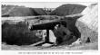
Along the
North Carolina coast, near
Wilmington, guarding the port longest open to blockade-runners, lay these far-flung earthworks.
Heavy timbers were heaped fifteen to twenty-five feet thick with sand, sodded with luxuriant marsh-grass.
Below appears some of the destruction wrought by the fire of the
Federal war-ships.
Here are the emplacements next to the angle of the work on the left of the sea face, and a bomb-proof under the traverse.
The first gun on the right is a 10-inch Columbiad dismounted by the assailants' fire.
Only the old-style two-wheeled wooden carriage, without chassis, can be seen, at the top of the bank — ready to tumble over.
The next gun is also a 10-inch Columbiad which has been knocked off its wooden barbette carriage; the third, a 63/8-inch rifle, on a two-wheeled wooden carriage.
The carriage has been knocked entirely off the bank, and is lying in the pool of water.
The only gun left mounted is the 10-inch Columbiad to the left.
The Fort finally succumbed to the terrific fire of the Federal fleet on January 15, 1865.
 | |
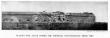
Sea face of Fort Fisher--mightiest fortress of the Southern Confederacy |
|  | |
Behind the ramparts of Fort Fisher--havoc from Federal shells |
|
[
266]
that the
Confederates required negro laborers to work under fire, and to their credit be it said that they performed their task with apparent willingness.
The engineer troops were the last to leave the city of
Petersburg, for the destruction of the bridges devolved upon them.
They retired from the north bank of the river early in the morning of April 3, 1865, under a scattering fire from the advance guard of the
Federals.
Then followed a day's march to Goode's Bridge, and the crossing of the
Appomattox River at that point, not only of the army and its wagon trains, but also of a large number of other wagons, carriages, buggies, and riders on horseback, Government and State officials, bank-officers with their specie, and many private individuals seeking safety for themselves and their belongings.
It had been planned to use the newly built Bevill's Bridge, which was the nearest to
Petersburg, for the troops and trains from that point, Goode's Bridge for troops from
Richmond, and a pontoon bridge at
Genito for all not connected with the army; but by reason of high water, which covered the approaches, Bevill's Bridge was useless.
The pontoons for
Genito, which were ordered from
Richmond two days before, failed to arrive, and thus everything converged at Goode's Bridge and the railroad bridge at
Mattoax.
This awkward situation was relieved to some extent by hurriedly laying a rough plank flooring over the rails on the railroad bridge, which made it practicable for vehicles to cross at
Mattoax.
The crossing to the south side of the
Appomattox River having been effected in some confusion, but, owing to the light of the moon, without accident, both the railroad and pontoon bridges were destroyed before daylight; and the engineer troops moved on to
Amelia Court House, where some rest but very inadequate rations awaited them.
Soon orders came from
General Lee to push on to Flat
[
267]
 |
|
Fort Fisher effect of the naval bombardment of December, 1864
In 1864, a larger force than ever had assembled under one command in the history of the American navy was concentrated before Fort Fisher, North Carolina, under Admiral David D. Porter. Sixty vessels, of which five were ironclads, arrived in sight of the ramparts on the morning of December 20th.
After a futile effort to damage the Fort by the explosion of the powder-boat Louisiana on the night of December 23d, the fleet sailed in to begin the bombardment.
The New Ironsides, followed by the monitors, took position as close in as their drafts would permit.
The Minnesota, Colorado, and Wabash followed near.
With a deafening roar and a sheet of flame, these frigates discharged their broadsides of twenty-five 9-inch guns, driving the garrison into their bomb-proofs.
On Christmas Day, the bombardment was resumed by the larger vessels and the ironclads, while the smaller vessels covered the landing of General Butler's troops from the transports which had just arrived.
The Fort proved too strong to take by assault, and the troops were withdrawn.
The Fort did not fall until January 15, 1865.
This photograph shows the effect of the terrific bombardment of the Federal fleet. |
[
268]
Creek, where the failure of an old country bridge and the absence of practicable fords delayed the crossing of that stream.
The outlook at that point on the line of march was evidently disturbing to
General Lee, for on arrival of the engineer troops late in the afternoon, for which he had waited, he impressed upon the colonel in command of them the necessity for strenuous efforts to effect as rapid a crossing of
Flat Creek as possible, emphasizing his instruction by saying that a captured order from
General Grant to
General Ord, who was at
Jetersville, indicated an attack early next morning.
Timber was felled; a new bridge was built; the last vehicle had passed over it, and the engineer troops were already in motion toward
Amelia Springs, when a Federal battery unlimbered on a near-by hill and fired a few shells to expedite the movement of as tired and hungry a body of Confederate troops as could have been found that morning in
General Lee's army, where fatigue and hunger were familiar conditions.
When the engineer troops, which had been rejoined by the companies detached for service north of the
James River and had made a respectable showing in strength, reached
Sailor's Creek, where the rear guard of the army was in line of battle, expecting an immediate attack, the general in command looked pleased and said they were just what he was looking for to reenforce a weak spot in his line.
To decline such an honor was not within the range of military possibilities, but an order from
General Lee, which a courier had been seeking to deliver, made it imperative to move on to the assistance of the wagon trains.
A heavy ordnance train, which was stalled in an effort to surmount a steep hill over a bad road and to cross a creek through swampy ground, was causing serious delay, and a number of wagon trains were parked in the fields, waiting for their turn to move on.
While this congestion was being partially relieved, the battle of
Sailor's Creek was fought, which resulted in defeat to the
Confederates, who were falling back in disorder toward
[
269]
 |
|
Where the sailors attacked — the mound battery at Fort Fisher
In this photograph unexploded 12-inch shells can be plainly seen upon the beach, as they fell on January 13, 1865, in the terrific fire from the Federal fleet under Rear-Admiral Porter.
This was the land face; the portion to the left was the angle of the work.
The land assault by the sailors on January 15th, was repulsed with a loss of some three hundred killed and wounded. At the western end of the works, however, the army under General Alfred H. Terry succeeded in effecting an entrance and captured the Fort that evening. |
 |
|
One of the huge traverses, after the bombardment
A traverse in an earthwork built perpendicular to the main work in order to limit the destructive area of shells.
The traverses at Fort Fisher rose twelve feet above the twenty-foot parapet, ran back thirty feet, and exceeded in size any previously known to engineers. |
[
270]
the still-delayed accumulation of wagon trains.
This caused a panic; traces were cut, and the drivers, mounted on the detached mules, abandoned their wagons and sought safety in rapid flight.
But the panic was not communicated to the engineer troops, which were formed in line across the road, in the belief that the broken ranks of their veteran comrades would re-form behind them, for no foe was in sight.
Such was the situation when
General Lee himself came back, followed by
Mahone with his division, which then became the rear guard.
The engineer troops, being placed under
Mahone's orders, moved in advance to the
Appomattox River at
High Bridge, and, in accordance with instructions, prepared to destroy the railroad bridge and the wagon bridge, after the troops and wagon trains had all passed.
The order to set fire to the bridges was so long delayed that, when it was done, the
Federals were close at hand, although not visible from the wagon bridge.
They made a dash and put out the fires before the structure, which did not burn readily, was seriously damaged.
In an ineffectual effort to recover and complete the destruction of the bridge, the engineer troops met with some losses in killed, wounded, and captured.
There were a day or two more of hunger and fatigue, and then the closing scenes at Appomattox Court House, on the morning of April 9th, which found the engineer troops in line to protect wagon trains, with the
Federal cavalry in their front.
Of the officers of the Engineer Corps of the Confederate army, few are left to give any account of their services.
Many of them were attached to the different commands in the field, quite a number of them were employed in making surveys and preparing maps for the use of the army, and others were in charge of the erection and enlargement of fortifications.
The records of the engineer bureau are said to have been removed when
Richmond was evacuated; but what became of them will probably never be known, except that some, if not all, of the maps fell into the hands of private individuals.


