Geographia
(
γεωγραφία). The world, as conceived of in the
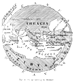
Iliad, is a round plain encircled by a great river, Oceanus—not the
Atlantic, of which Homer seems to have no knowledge at all, but a purely mythical stream. The
sky is a great concave roof propped up by pillars which the mighty
Atlas (q.v.) upholds. On the large, flat disc of the earth is a sort of
belt or zone, of which Homer appears to have a definite notion. It includes Greece, for
which, however, he has no collective name, since with him Hellas denotes only a district of
Thessaly (
Iliad, ii. 683). Acarnania and Epirus are not mentioned by name. On
the north of the Aegean, the Thracians are known, including the Paeonians along the Axius (ii.
850). In Asia Minor, the topography of the Troad is familiar to the poet; Lydia is mentioned
as Maeonia; while his references to the interior of Asia Minor—Phrygia, Pamphylia,
etc.—are vaguely indefinite. Of the Aegean islands, Crete, Rhodes, Tenedos, Imbros,
Samothrace (Samos), Lesbos, and Lemnos are specifically mentioned. Beyond this belt, Homer
knows little or nothing of the world. In the North, the milk-fed nomads are noted (xiii. 5);
in the South, the Aethiopes, “remotest of men,” are indicated. Near the
banks of Oceanus dwell the Pygmies. The Egyptian Thebes (ix. 381) and Sidon (vi. 289) occur,
and the word “Phœnician” appears once (xxiii. 744).
The
Odyssey represents a more extended geographical knowledge. Chios is
mentioned; and so are Delos, the Dorians, Ithaca, and Sicily. The Phœnicians are now
well known; the Aethiopes
 |
|
The World according to Homer.
|
are now clearly defined and divided into two sections, the eastern and the western.
Scylla and Charybdis, the Lotus-eaters, and the Phaeacians are new. All this, however, is hazy
and obscure. (See Jebb,
Homer, ch. ii. [Glasgow, 1887].)
The Phœnicians and their kinsmen, the Carthaginians, by their commercial
enterprise, did much to secure a knowledge of the coast of Africa, and sailed westward as far
as the Canaries. Herodotus speaks of them as circumnavigating Africa. A famous voyage was that
of
Hanno (q.v.), the Carthaginian, who seems to have
gone beyond what is now Sierra Leone. But geographical study and geographical literature took
their rise, like historical literature, among the Ionian Greeks of Asia Minor. Their extensive
commerce and their activity in founding colonies enlarged their geographical horizon. The
necessity was thus felt of utilizing and recording the knowledge already
 |
|
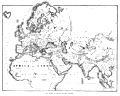
The World as known to the Romans.
|
acquired for the purpose of discovering the form and constitution of the earth. The
first attempt at outlining a map of the world was made by Aristagoras of Miletus about B.C.
550. His kinsman Hecataeus, one of the writers called
λογογράφοι, who flourished about fifty years later, corrected and enlarged this
map and added a commentary. (See
Logographi.)
This commentary, of which only fragments are preserved in quotations, is the oldest piece of
purely geographical writing in Greek. The geographical chapters in the history of Herodotus
(about B.C. 450) compensate us to a certain extent for the loss of this work, and of the other
works of the
λογογράφοι on history and geography; but they
treat only the eastern half of the then known world. It became, indeed, in the absence of a
regular tradition of geographical science, a usual thing for historians to insert
geographical disquisitions into their works. The writings of Thucydides, Xenophon, Ctesias,
Ephorus, Theopompus, Timaeus, and others down to the time of Polybius, afford examples of
this.
The first purely geographical work which has come down to us in a complete state is the
Periplus (
Περίπλους), bearing the name of
Scylax, written in the first part of the fourth century B.C. It is a description of the coast
of the Mediterranean Sea. About the same time the astronomer Eudoxus of Cnidus made a great
advance in the theory of physical geography. It was he who first adduced mathematical proof of
the spherical shape of the earth, which had been asserted before his time by Pythagoras. The
division of the globe into five zones (two frigid, two temperate, and one torrid) is also due to him. About B.C. 330, Pytheas of Massilia (Marseilles) explored towards
the northwest as far as the northern end of the British Islands and the coasts of the German
Ocean. About the same time, the campaigns of Alexander the Great opened up Asia as far as
India to Greek research. Nearchus made a report of exceptional value on his coast voyage from
the Indus to the Euphrates. All these discoveries were embodied, about B.C. 320, in a new map
by Dicaearchus of Messana, a disciple of Aristotle. He was the first scholar who treated
physical geography in a scientific manner. He assumed the existence of a southern hemisphere,
and made an estimate of the earth's circumference, to which he gave the exaggerated
measurement of 40,000 miles. His map remained for a long time the standard work of the kind.
The southern and eastern parts of India were still further opened out under Alexander's
successors, in consequence of the campaigns of the Seleucidae, and several journeys were
undertaken by ambassadors, among which that of Megasthenes should be mentioned. The commercial
expeditions of the Ptolemies resulted in fresh knowledge of the coasts of Arabia and East
Africa.
The first person to arrange the mass of geographical material, hitherto collected, into a
really scientific system, was
Eratosthenes
(q.v.) of Cyrené (about B.C. 276-175). He found his materials in the rich
collections of the Alexandrian Library, Alexandria being then the central point of the
commerce of the world. He was fully equipped for his task by his acquirements both in physical
science and mathematics, and in history and philology. He endeavoured for the first time to
estimate the earth's circumference by a measurement of degrees carried out over a space of
fifteen degrees of latitude, though the imperfection of his method brought out too large a
quantity. The name of Hipparchus of Nicaea (about B.C. 140) marks a considerable advance. He
may be called the founder of mathematical geography, as he applied geographical length and
breadth to determine the position of places on the earth's surface. He also superseded the
rectangular and equidistant projection of parallels and meridians, hitherto used in maps, by a
projection which, with few modifications, is identical with the one now in use. The parallels
were represented by segments of a circle, the meridians by straight lines or curves,
corresponding with the
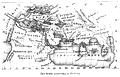 |
|
The World according to Ptolemy.
|
portion of surface to be represented, drawn at distances corresponding to the actual
distances on the surface of the globe. The estimate of the earth's circumference, which was
accepted as correct down to the tenth century A.D., was that of Posidonius of Apamea (about
B.C. 90). Taking as his basis the measurement of the shortest distance from Alexandria to
Rhodes, he brought out the result as 4500 geographical miles, or too little by nearly
one-sixth.
Only fragments remain of the writings of these geographers, and others contemporary with
them; but we possess the great work of Strabo of Amasia, finished about A.D. 20, the most
important monument of descriptive geography and ethnology which has come down from Greek
antiquity. Thanks to the Roman conquest, he was in a position to give a more accurate
description of the West than his predecessors. Up to this time all that the Romans had done
for geographical research was to open up Western Europe and Northern Africa to the Greek
scientists. An immense service was rendered to science by Agrippa, under the direction of
Augustus. He measured and indicated on a map the distance between the stations on the great
military roads and along the coasts of the Roman Empire, thus contributing enormously to our
knowledge of ancient topography, and laying a foundation for our maps. These data formed the
basis of a new map of the world, which was first set up in Rome. Numerous copies were probably
taken for the larger cities of the Empire, and smaller portable ones distributed among the
military and the administrative officers. It is probably upon copies of this kind that the
Itineraria and the
Tabula Peutingeriana are based. See
Itineraria.
In the first century A.D. much was added to geographical knowledge by the expeditions of the
Romans into the interior of North Africa and the North of Europe. About A.D. 50 Apollonius of
Antioch explored India, going beyond the Punjab and possibly as far as the Ganges. The most
important literary works of the Romans on geography belong to this period. These are
1.
the compendium of Pomponius Mela;
2.
the geographical books of Pliny the Elder's great encyclopaedia (
Historia
Naturalis), an uncritical compilation, but the only representative we have of a
number of lost works; and
3.
the
Germania of Tacitus, an essay mainly of an ethnographic character. The
last great contribution made to geographical science in antiquity is the work of the
Alexandrian astronomer Ptolemy (about A.D. 150). This consists mainly of lists of the places
marked on the current maps which he makes his authorities, with their latitude and longitude.
After Ptolemy, the geographical literature of the Greeks and Romans alike has nothing to show
but compilations and extracts. Towards the end of the sixth century, Stephanus of Byzantium
compiled a dictionary of geography, which is valuable for the quantity of information taken from the older and lost writings which it embodies. The book of
Pausanias (about A.D. 175) is valuable as bearing on the special topography of Greece.
Cosmus, called Indicopleustes, wrote in the reign of Justinian a work called
Topographia Christiana, giving an account of India. In it occurs the first
mention by name of China. See Bunbury,
History of Ancient Geography, 2 vols.
(1883); St. Martin,
Histoire de Géographie;
Riese, Geographica (1881);
Schmidt, Zur Geschichte der
geographischen Litteratur bei Griechen und Römern (1887);
Berger, Geschichte der wissenschaftl. Erdkunde bei den Griechen
(1891); and
Antichan, Les Grands Voyages de Découvertes des
Anciens (1891). The remains of the
Geographici Graeci Minores
are edited by C. Müller, 2 vols.
(Paris, 1882); the
Geographi
Latini by Riese
(Frankfort, 1878).


