[
219]
Engineer corps of the Federal army
O. E. Hunt, Captain, United States Army
 | |
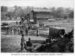
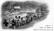
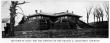
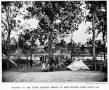
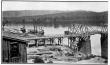
Pontoniers on the day of battle: rowing the pontoons into place, for Sedgwick to cross to the rear of Lee's army — Rappahannock river, May 3, 1863 |
|
[
220]
Engineers.
The rapid movement of an army and its supplies wins victories and makes possible the execution of effective strategy.
Road-making is no less essential to the success of a soldier than the handling of a musket.
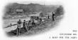
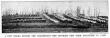
The upper photograph shows
Major Beers of the Fiftieth New York Engineers, on horseback, directing his battalion at road-making on the south bank of the
North Anna River May 24, 1864.
A wagon-train of the Fifth Corps is crossing the bridge by
Jericho Mills, constructed on the previous day by
Captain Van Brocklin's company of the Fiftieth New York Engineers.
In the lower photograph
Major Beers has apparently ridden away, but the soldiers are still hard at work.
The wagon-train continues to stream steadily over the bridge.
 | |
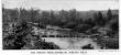
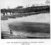
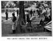
The Engineers dig a road for the army |
|  | |
50th N. Y. Hard at work in Grant's advance, May, 1864 |
|
[
221]
 |
|
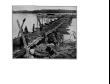
A closer view making the dirt fly
Here the reader comes closer to the line of sturdy engineers exerting their muscles in behalf of the Union.
The train is over the bridge by this time; only a single wagon is seen, probably attached to the engineer corps.
Farther up the river a number of the men not on this detail have gone in swimming.
A couple of tents are visible on the bank near the end of the bridge.
The busy diggers do not even glance at the men floating on the river below.
They are making a road where an army has to pass.
Many new ways had to be constructed to enable the supply trains to reach their various commands.
South of the river Sheridan's cavalry was operating.
There were continuous engagements on the line of the North Anna River from May 22d to 26th, and at any moment the Confederates might appear from the woods and open fire on the engineers. |
[
222]
In modern military operations, no more striking examples of the importance of engineer troops and their work can be found than in the
American Civil War. For much of the country over which this great struggle was waged, proper maps were wanting, and frequently roads and bridges had to be built before military movements could be executed.
Rivers had to be bridged by pontoons and semi-permanent structures; entrenchments and fortifications had to be constructed when Camp was made or a definite position taken for defense or siege, and finally, the men doing this had always to consider the laying-aside of axe and spade, and, shouldering the musket, take their place on the firing-line, where they gave an account of themselves second to none of the combatant organizations.
Such conditions of warfare were in striking contrast to those under which the great wars of
Europe had been fought, for in the campaigns of Frederick, of
Napoleon, and of
Moltke, practically every inch of the territory was known and mapped.
Military operations took place where well-built roads made travel easy; where permanent forts and walled cities were found, and fighting in swamps or on mountaintops was unknown.
In short, with the formal military science of the day, the
American engineers so combined characteristic ingenuity and the lessons of civil life that the progress and success of the battling ranks were made possible under conditions never before encountered in a great war.
The inception of the present Corps of Engineers in the
[
223]
 |
|
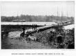
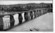
When the bridge was finished at Franklin's crossing April 29, 1863
Hopeful and proud these pontoniers of Hooker's engineer battalion stand upon their just-completed bridge — rushed across in one hour and ten minutes. The bridge “train,” wagons and boats, had been masked about a mile from the river in dense woods.
Then the boats were carried to the river at night and were actually launched before the Confederates were aware of the enterprise.
Troops were ferried across in the face of musketry fire from the opposite bank, and the Confederates were driven off. Captain A. J. Russell, who took this photograph, followed close upon this action.
In photographs of Franklin's Crossing taken subsequently, the trees have been chopped down, but here the earth, freshly upturned to make an approach to the bridge, and the little pup-tents just going up across the river, both indicate that the soldiers have just arrived.
They were not aware that Jackson was to circle Hooker's right in the woods, take him in reverse and cut him off from United States Ford — and that he was to be huddled into a corner in the Wilderness, hurrying messages to Sedgwick's corps to come to his relief.
This bridge, three hundred and ninety feet long, was moved bodily to Fredericksburg and there placed in position on the following Sunday during the battle of Fredericksburg Heights, where Sedgwick finally stormed the position that four months before had cost Burnside nearly 13,000 men. This was one of the most successful exploits of the engineer corps during the entire war. |
[
224]
United States army was in 1802.
By the act of Congress, of the 16th of March of that year, it was established to consist of one engineer, with the rank of major; two
assistant engineers, with the rank of captain; two
assistant engineers, with the rank of first lieutenant; two
assistant engineers, with the rank of second lieutenant, and ten cadets.
The same act authorized the
President to make promotions on account of merit whenever he deemed fit, so that the corps, as finally constituted, should not exceed one colonel, one
lieutenant-colonel, two majors, four captains, four
first lieutenants, and four
second lieutenants.
The act also provided that the corps, thus constituted, should form a military academy at
West Point.
The charge and superintendency of the Military Academy remained in the hands of the
Corps of Engineers until July 13, 1866, when, by act of Congress of that date, control passed to the War Department at
Washington, and the direct management of the academy to such officers as might be detailed by the
President from any of the branches of the service.
The Corps of Engineers was thus responsible for the instruction of the officers whose services were invaluable to both the
Federal and Confederate armies during the memorable four years of the
Civil War.
When the war between the North and South began, there were two organizations of engineers, the
Corps of Engineers and the
Corps of
Topographical Engineers.
They were merged in 1863, and thenceforth existed as one organization.
By the act of Congress of August 3, 1861, the
Corps of Engineers was reorganized to consist of one colonel, two
lieutenant-colonels, four majors, twelve captains, fifteen
first lieutenants, fifteen
second lieutenants, forty sergeants, forty corporals, eight musicians, two hundred and fifty-six artificers, and two hundred and fifty-six privates — a total of forty-nine commissioned officers and six hundred enlisted men. At the same time the
Topographical Engineers were constituted with a total of forty-two commissioned officers.
At the end of the
[
225]
 |
|
Amateurs of 1861--United States engineers
This photograph exhibits some unformed engineers the first year of war, with all their experience before them.
They had built no bridges at that time, and were not inured to turning from their work to grasp a musket or tranquilly to continue their labor while the dead and wounded from the Confederate sharpshooters' bullets fell thick about them.
The uniforms and accouterments are new. |
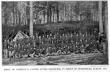
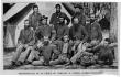 |
|
Professionals of 1864--group of company B, United States engineers
These veterans of Company B as they sit in their Camp outside of Petersburg are no longer amateurs, but professionals.
Their closeset mouths and steady eyes tell the story of Yorktown, Fredericksburg, along the Potomac and the James; of mighty siege works around Petersburg.
They are no longer spick and span as in 1861, but they look much more efficient in their army shirts and loose blouses. |
[
226]
Civil War, the corps consisted of a total of one hundred and five commissioned officers and seven hundred and fifty-two enlisted men.
The duties required of the corps during the war were multitudinous, but consisted principally in planning, tracing, and superintending the construction of all fortifications, of whatever nature, needed in military operations, whether these works were of a temporary or a permanent character; and also in planning, laying-out, and constructing all works needed for the attack or the defense of fortifications.
The corps was charged with the duty of securing and reporting upon the topographical features of the country through which the armies were operating, to the extent of furnishing maps and detailed descriptions sufficiently clear and accurate to permit the
commanding generals to order the movement of troops with certainty as to the ground over which these troops were to maneuver.
On the field of battle, the exact knowledge of the terrain often decided the result, and the advantage was with the officers who had the best maps.
On both sides these were furnished by the
engineer officers.
They were frequently charged with the duties of selecting positions for camps, either fortified or otherwise, and of reconnoitering the positions of the foe. They had charge of the bridge-equipage of the armies, and under their supervision were built the great structures used for the passage of immense bodies of men over the rivers of the
South.
Engineer troops were instructed in the arts of sapping, mining, building pontoon bridges, and quickly constructing “hasty entrenchments.”
Engineer officers not on duty with troops were utilized on the staffs of the
commanding generals.
At the outbreak of the war, there were practically no engineer troops — only one small company, which had been organized during the
Mexican War. By the act of Congress of August 3, 1861, already referred to, a battalion of four
[
227]
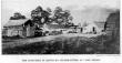
Blockhouses.
This blockhouse was near
Hunting Creek, close to the Orange & Alexandria Railroad, and covering the bridge over the creek on the
Telegraph Road.
The walls were built of large logs from sixteen to eighteen inches in diameter.
Loop-holes for musketry were cut through the walls, just above the earthern bank, and were “splayed,” or widened, toward the inside to permit a greater field of fire.
Embrasures for 12-pound howitzers were cut on every face.
Two such guns were placed in each blockhouse of this type.
Each was provided with a magazine below the floors, arranged for a garrison of sixty men. The second picture shows a square blockhouse near the
Virginia end of Aqueduct Bridge.
This structure had two stories, with the upper projecting over the lower, and loop-holes in the floor of the upper story to permit the defenders to fire down on the heads of assailants near the walls.
The entrance was through the door in the upper story, to which access was gained over the drawbridge from the top of the trestle.
These blockhouses had not much strength, and were useful chiefly for moral effect, although, in case of necessity, a stubborn resistance could have been put up by defenders.
 | |
Blockhouse near Hunting Creek built for the defense of the Orange & Alexandria railroad |
| |
[
228]
companies was provided for, and was assigned to the Army of the Potomac.
It was utilized in constructing the defenses of the city of
Washington in the winter of 1861-62, and during that time received instruction in the duties which it afterward performed so well in the field.
On February 24, 1862, the battalion was sent to
Harper's Ferry, Virginia.
There, under the greatest of difficulties, it constructed a pontoon bridge across the
Potomac.
The river was a raging torrent, the water being fifteen feet above the normal level, and filled with huge cakes of drifting ice and quantities of debris.
It was with the utmost exertions that the pontoons could be pulled into position, and, once placed, they had to be secured with ships' anchors and chain-cables.
But the structure was completed in about eight hours, and
General Banks' corps, with all its trains and artillery, crossed safely and without delay.
For a time the battalion was engaged in keeping the bridge in position and in good repair.
General McClellan, himself an engineer of renown, stated in a letter to
Secretary of War Stanton that it was one of the most difficult operations of the kind ever performed.
Immediately after returning to
Washington from
Harper's Ferry, the engineer troops, with their bridge-equipage, were sent to
Fort Monroe, in Virginia, and were moved thence, on April 4th, to a Camp near
Yorktown, in preparation for the
Peninsula campaign.
In front of
Yorktown the battalion was engaged in constructing trenches and lines of communication, and in superintending and instructing details of soldiers who were unfamiliar with methods of modern warfare.
At this period of the war (1862), the troops of the infantry and the cavalry had received no training in the construction of field-fortifications.
Consequently, the duty fell heavily on this battalion of men who had received such instruction.
Orders to construct a bridge across the
Chickahominy River were received late on the afternoon of the 31st of May.
The river was rising rapidly, and the night was extremely dark.
[
229]
 |
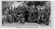
|
The men who made maps — topographical engineers before Yorktown
This photograph of May, 1862, affords the last chance to see the Topographical Engineers at work as a distinct organization.
At the time this view was taken they still existed as a separate branch, their duties were the compilation of maps and other topographical data for the use of the army; but by act of March 3, 1863, the Corps of Topographical Engineers was abolished and merged into the Corps of Engineers.
Time and again on the field of battle the exact knowledge of locality decided the result.
Great advantage lay with the officers who had the most reliable and detailed maps.
None such existed of the theater of war in Virginia, and on this corps fell the duty of providing all topographical data necessary for the Army of the Potomac.
The officers were all highly trained in engineering work, especially in the surveys necessary for their maps, and in their preparation.
In this photograph is a surveyor's level, and on the table a map in process of preparation.
The enlisted men in this corps were of very high caliber and their work was of inestimable value. |
[
230]
Consequently, the work had to be postponed until daylight, but communication was opened with the opposite bank by 8:15 A. M. Soon another span was built, and the troops were engaged in road-making in the vicinity of the two river-crossings, to keep open the passages across the low, swampy lands through which the river runs.
A third structure, of combined cribwork and trestle, was then constructed, some distance below the two pontoon bridges.
Of this last passageway,
General Barnard,
chief engineer of the Army of the Potomac, remarked that it was an excellent structure, capable of bearing all arms and affording direct communication, in place of that by the inconvenient roads across the pontoon bridges.
At
Mechanicsville and
Gaines' Mill, the engineer troops did valiant service in the construction of trenches and other field-works.
By this time the other troops were gaining the necessary experience, and toward the end of the
Peninsula campaign the hastily constructed entrenchments of the entire army were models of completeness and speed in building.
Road-work, in this desolate region, was of the most fatiguing kind, but was well and thoroughly done.
The few men available from the engineer battalion aided as the instructors of the other troops engaged, and, by the time the movement began toward
Malvern Hill, nearly all the troops of the Army of the Potomac had become accomplished in the arts of roadmaking, bridge-building, and entrenching.
At
Malvern Hill, the engineer battalion was posted as infantry, after preparing the front of the line by “slashing” or felling trees, to impede the advance of the
Confederates and to afford an open field of fire to the defending troops.
After leaving
Harrison's Landing on the withdrawal from the
Peninsula, the battalion was sent to
Fort Monroe to replenish its materiel, and thence to the mouth of the
Chickahominy, where, in a short time, a fine pontoon bridge was constructed for the passage of
McClellan's entire army.
This bridge was 1980 feet long, and for the most part was
[
231]
Engineers, East and West
When the war broke out,
General John Gross Barnard had just published “Dangers and Defences of New York” (1859) and “Notes on sea-coast Defence” (1861). He was immediately summoned to
Washington as chief engineer in charge of constructing the defenses.
Later he became chief engineer of the Army of the Potomac with the rank of brigadier-general and chief engineer of
General Grant.
General Barnard had graduated from the Military Academy at
West Point in the class of 1833, fought through the
Mexican War, where he fortified
Tampico, and was for four years in charge of the defenses of New York.
At the close of the war he was brevetted major-general.
General O. M. Poe did for
Sherman in the
West what
General Barnard did for
Grant in the
East.
He labored constantly in the construction of defenses for the numerous bridges along the line of railroad, fortified many strategic points, made surveys and issued maps, and secured an invaluable photographic record of the engineering in
Sherman's campaigns.
Many examples are reproduced in this History.
[
232]
built by successive pontoons — placing the boats in the bridge, one at a time.
A portion was built by rafts — i. e., by building a long section separately and placing it in position when complete.
The floor was covered with straw to prevent wear.
Competent authorities characterized this structure as one of the most extensive known to military history.
On August 18th, after the army had crossed the river, dismantling was begun, the parts being placed in the pontoons, and, within five hours after the work was commenced, rafts of pontoons had been made up, and the whole was on the way to
Hampton, near
Aquia Creek, on the
Potomac.
These troops rendered invaluable service at the
battle of Antietam.
The night before the conflict they made three of the fords of
Antietam Creek possible for artillery, by cutting down the banks and paving the bottom, where it was soft, with large stones.
After the battle, by request of its officers, the battalion was assigned to duty as infantry, and it supported one of the batteries in the advance, when the
Federals moved away from the
Antietam, several weeks later.
On December 11th, a bridge was thrown across the
Rappahannock, under fire, at a point known as Franklin's Crossing.
Troops embarked in pontoons and were ferried across.
Then they stormed the
Confederate rifle-pits on the river bank and held them until the passageway was completed.
After the
battle of Fredericksburg the pontoons were removed.
The following winter, in 1863, a reorganization took place, and the
Corps of
Topographical Engineers was merged into the
Corps of Engineers.
During the
Chancellorsville campaign, April and May, 1863, the battalion again constructed a bridge across the
Rappahannock at Franklin's Crossing.
The bridge train was massed about a mile from the river, in dense woods.
At night the boats were carried by infantrymen to the river, without the
Confederates being aware of the movement until the boats were actually in the water.
Troops were ferried across in the
[
233]
 |
|
A few weeks before the Wilderness — the fiftieth New York engineers in camp
The tents in this winter Camp at Rappahannock Station, March, 1864, are substantial and roomy wooden huts roofed with tent canvas.
To the left is the park of the train.
The pontoon-boats are ready on their wagons.
All the bridge material awaits transportation. |
 |
|
Two months later in 1864: the engineer corps at work
Lee's army, in retiring across the North Anna River before Grant's army in May, 1864, destroyed the permanent bridge at this point.
By the summer of 1864 half an hour sufficed for the experienced engineers to lay a bridge like this, after the arrival of the bridge train. |
[
234]
face of musketry fire from the opposite bank.
After the Southerners had been driven away, the bridge, three hundred and ninety feet long, was built in one hour and ten minutes. Another was immediately laid, and during the
battle of Fredericksburg Heights these two were moved bodily to
Fredericksburg and there placed in position.
On May 4th, the materiel was hastily removed to the north bank, and the last plank was scarcely up when a force of Confederates appeared on the opposite shore.
Between
Chancellorsville and
Gettysburg, the engineers were engaged in building roads and bridges in the lines of the
Federal army, and the individual officers, not on duty with the troops, were employed in reconnaissances, map-making, and on duty as staff-officers.
Through
Gettysburg, back to
Virginia soil, and on toward
Richmond, the weary army again took its way, and throughout all the attendant hardships the faithful engineers worked for the welfare and efficiency of the other troops.
There were numerous occasions during which they had to submit to fire from the opposing army without any opportunity to reply.
Their duties were too important to permit them to suspend operations for so trivial an annoyance as being shot at.
The appointment of
General Grant to the command of all the armies of the
United States in the field, marked a turning-point for the troops of the Army of the Potomac, especially affecting the Engineer Corps.
On March 10, 1864, he visited that army, the headquarters of which were near
Brandy Station, in Virginia, and announced his intention of remaining with it in future campaigns, leaving
General Meade in direct command, and transmitting all orders through him. The army was then lying on the north bank of the
Rapidan.
Accurate maps and topographical information of the country between the
Rapidan and
Richmond were much needed.
Reconnaissances had been made as far as the fords of the
Rapidan, and that part of the country was well known,
[
235]
Canvas pontoon boats.
When dismantled, the canvas pontoon boats occupied a surprisingly small space.
Thus the capacity of a train for bridge material of this kind was very much greater than for that of the wooden pontoons.
The latter, however, gave better and more lasting service.
The canvas became water-tight if well soaked.
These pontoon boats were “knocked down” to be transported; the canvas was folded into a compact bundle and stowed in one of the wagons of the train.
The parts of each boat were always kept together, so that they could be assembled at any time.
The canvas, all in one piece, was laid out smooth on the ground, the bottom pieces of the frame put in place, the tenons of the uprights and the braces inserted in their corresponding mortises, the gunwales together with the end-pieces placed on the top, and the canvas then brought up over the sides and lashed tightly over the gunwales, by ropes eye-spliced into the eyes of the sides.
The inside end-pieces were then carried around the bow and stern and lashed, and the outer pieces brought up over the ends and lashed in the same manner as the sides.
The boat was then allowed to soak in the water for a time.
Each boat was twenty-one feet long, five feet wide, and two and a half feet deep.
 | |
A canvas pontoon boat assembled ready for business--March, 1864 |
| |
|
[
236]
 |
|
Benham's wharf at Belle Plain: one month before his famous bridge across the James
“Belle Plain, Upper Wharf, erected by Engineer Corps, General Benham, Chief, May 15, 1864.”
So reads the inscription made by the photographer on his negative.
The few words recall important events.
At this time Grant was in the midst of his unsuccessful attempt to circumvent Lee and the Army of Northern Virginia at Spotsylvania.
The work shown in this photograph was but child's play compared with the undertaking just one month later, when Grant finally decided to cross the James.
One hour before noon on June 15th, General Benham received orders to prepare a pontoon-bridge across the James River for the passage of the entire army.
In anticipation of this order, pontoons had been sent from Fort Monroe, and the work was started under Major Duane. General Benham reported to General Meade at the position selected, and was directed to proceed at once with the construction.
General Meade smiled at the enthusiasm of Benham when he remarked that he would not sleep till the bridge was finished.
About five and a half hours after Benham's arrival, a telegram was received from General Meade inquiring about the progress of the work.
The indefatigable engineer was able to reply that the last bolt was in position, and that the troops could begin to move when they wished. |
[
237]
[
238]
and the movements of the army between that river and
Mine Run in
Virginia, in November and December, 1863, had furnished considerable information concerning that region.
The latter experience had proved that the existing maps of the country to be traversed were valueless for the purposes of marching and fighting an army.
The country was of the worst topographical nature possible, and, although in one of the oldest States of the
Union, there were but few reliable maps.
Consequently, this information had to be obtained in advance of the army.
A party composed of regular and volunteer officers and soldiers, under
Colonel N. Michler, of the Engineer Corps, was directed to undertake this work.
Their labors commenced after crossing the
Rapidan.
Every road within the lines of the army had to be surveyed and mapped, and the work extended as far as possible to the front and the flanks.
The maps were immediately reproduced on the field and distributed as far as time would permit.
Revised editions of the maps were published as often as new information was collected.
In this way, several editions of eleven maps were arranged and issued, comprising surveys covering an area of seven hundred and thirty square miles.
These were also corrected by instruments carried by the supply train and by maps captured from the
Confederates.
Before the army started from its winter quarters on the north of the
Rapidan, in the spring of 1864, for the last great campaign, there had been twelve hundred maps made and issued.
After the start, and before the end of the siege of
Petersburg, about sixteen hundred were issued from new surveys.
In addition to the duties of surveying the country and making and distributing maps, the officers of the corps were charged with the work of selecting positions and directing their fortification.
On the morning of the 3d of June, a gallant assault by the whole Union army was directed against
[
239]
Pontoon-bridges.
Strips of water a few hundred feet wide often nullify the plans for entire armies.
This page of pontoon-bridges gives some idea of the inestimable services of the Engineer Corps.
In the upper photograph is one of the pontoon-bridges across the
James, at
Powhatan Point, near
Harrison's Landing, which was used by part of
General Grant's army in the march from Cold Harbor to
Petersburg.
Below to the left is shown a pontoon-bridge over the
James with a movable draw, to let vessels pass through.
On the right is the pontoonbridge at
Broadway Landing on the
Appomattox, over which
General Smith's corps moved to make the first attack on
Petersburg.
 | |
Pontoon-bridge where Grant crossed the James in June, 1864 |
|  | |
Pontoon-bridge across the Appomattox |
|
 | |
Pontoon-bridge with an open draw |
|
[
240]
the
Confederate entrenchments at Cold Harbor.
But the
Federals were baffled in their attempts to drive the
Confederates across the
Chickahominy.
Colonel Michler, with his officers, was directed to assist
Major Duane,
chief engineer of the Army of the Potomac, in making a reconnaissance of the
Confederate positions to ascertain their strength.
Never were two lines of battle more closely arrayed.
At places they were separated by no more than forty to one hundred yards, the men hugging the ground closely, and each army silently awaiting the determined attack of the other.
The mettle of each had been felt and keenly appreciated by its opponent.
Colonel Michler and
Major Duane made a careful examination of the location of the two lines, and reported to
General Grant and
General Meade the impracticability of storming the
Confederate position, especially in front of the Second and Eighteenth corps, there being no suitable place in the rear for the massing of troops for an attack.
The army was then directed to entrench on lines to be selected by the
engineer officers, and until the 9th of June it lay confronting the
Confederates.
On that date,
Michler and
Duane were ordered to select a line in rear of that occupied by the army, to be held temporarily by two divisions, which would enable the army to retire and move again by the flank, under cover.
The lines were chosen by the engineers.
Entrenchments were planned, and the troops began fortifying.
At the same time, several of the engineer officers continued the reconnaissance to determine the best route for the contemplated movement.
On the 13th of June, by direction of the
commanding general, engineer detachments proceeded in advance of the army to the
James River, to reconnoiter the ground along its banks for two purposes--first, to enable the army to cross to the south side, and second, to fight a battle, if necessary, to rotect the crossing.
Lines covering the point of crossing were selected, entrenched, and held.
Colonel Michler was
[
241]
Constructing a pontoon bridge.
To construct a pontoon bridge the first boat launched was rowed up-stream a short distance.
The anchor was let go. Its rope was then paid out sufficiently to drop the boat down into position.
A second anchor was dropped a short distance down-stream, if the current proved irregular.
The second boat was placed in position by the same process.
Then the sills of the bridge, called “balk,” could be placed across by floating the second boat alongside the first, placing the ends of the balk, usually five in number, across the gunwale, and then shoving the boat into position by pushing on the inner ends of the balk.
These ends had heavy cleats so that they could be engaged over the further gunwale of each boat.
The third boat was then placed in position by repeating the process.
Then the “chess” layers commenced.
The “chess” were the boards forming the flooring of the bridge.
After the floor was laid the side rails, visible on the top of the flooring, were laid, and lashed to the balk through slits which were left between the boards for that purpose.
This stiffened the whole structure and held the floor in place.
Usually an up-stream anchor was necessary on every boat, and a down-stream anchor on every second or third.
The floor of the bridge was usually covered with earth or straw to deaden the sound and preserve the chess.
In these two photographs the engineers are just completing a bridge across the
James.
 | |
Soldiers by the upper pontoon bridge at deep bottom — James river, 1864 |
 | |
The group shifts — the sentry returns |
|
[
242]
then directed to locate a line on the south side where the Second Corps, after crossing, could entrench and protect the remainder of the army during the dangerous movement.
One hour before noon, on June 15th,
General H. W. Benham, of the Engineer Corps, was ordered by
General Grant to prepare a pontoon bridge across the
James River for the passage of the army.
In anticipation of this order, pontoons had been sent from
Fort Monroe, and work was started under direction of
Major Duane.
General Benham was at
Fort Monroe when he received the order, but arrived at the site of the bridge, just above Fort Powhatan, about five o'clock in the afternoon.
The work was accomplished by four hundred and fifty men under the immediate command of
Captain G. H. Mendell, of the regular service, who had for this purpose a body of regulars and volunteers under his charge.
General Benham reported to
General Meade at the position selected, and was directed to proceed at once with the construction.
General Meade smiled at the enthusiasm of
Benham when he remarked that he would not sleep until the bridge was finished.
The regulars were placed at the east end and the volunteers at the west end, and work was commenced on several parts of the bridge simultaneously — by the method known to the engineers as that of “simultaneous bays.”
About five and a half hours after
Benham's arrival, a telegram was received from
General Meade asking the progress on the bridge, and the engineer was able to reply that the last bolt was in position, that a gap had been left, according to orders, but the bay necessary to connect the span was ready, and that in fifteen minutes from the time the order was given the communication would be complete from shore to shore, a distance of twenty-two hundred feet.
The gap was closed, but the bridge was not required until six o'clock in the morning of the next day. At that time the regulars were relieved, and the bridge continued under the charge of the volunteers until it was dismantled, three days
[
243]
 |
|
The Dutch gap canal: November, 1864-digging: April, 1865-completion
After General Beauregard had repulsed the attempt of General Butler to move along the south bank of the James on Richmond, and had “bottled up” Butler at Bermuda Hundred, the Federal commander cast about for other means to accomplish his object.
The opposing lines of entrenchments touched the river at Trent's Reach, a broad and shallow portion of the James completely commanded by Confederate batteries.
Moreover, General Butler himself had built a line of obstructions across it after his retreat from Drewry's Bluff, much against the advice of the naval men in the river.
The army seemed more afraid of the Confederate flotilla than were the men who would have to fight it on water.
Butler had been fearful, however, that he would be cut off from his base of supplies at City Point, so he ordered the vessels to be sunk in the channel and made the formidable obstructions a mile south of the Bluff, where the Confederates soon built Battery Dantzler.
The river, however, was so crooked that two miles below Trent's Reach at Dutch Gap, only 174 yards separated the lower river from the upper.
If the Federals could cut through this neck, they could avoid the Confederate works and move on up the river by boat as far as the works at Chaffin's Bluff and Drewry's Bluff. Captain Peter S. Michie, of the United States Engineers, later a brigadier-general, was detailed to dig a canal through at Dutch Gap.
This would cut off four and a half miles of river.
The excavation was forty-three yards wide at the top, twenty-seven at the water level, and thirteen and five tenths yards wide at a depth of fifteen feet below water-level.
It was ninety-three feet deep at the northwest end and thirty-six feet deep at the southeast end. The total excavation was nearly 67,000 cubic yards.
The greater portion of the digging was done by colored troops who showed the utmost bravery under the constant fire of the Confederate batteries on the river. |
[
244]
later.
The repairs and the adjustments required during the continuous use of the bridge were attended to by the volunteers.
Beginning at six o'clock in the morning of June 16th, a continuous column of wagons (nearly six thousand), nearly all the artillery, cavalry, and infantry present, together with more than three thousand head of beef-cattle for the Subsistence Department continued to cross the bridge for forty hours, without a single accident to man or beast.
The officers and men in charge of the bridge were allowed very little sleep during this time, and
General Benham relates that he had only about four hours sleep in the eighty that the bridge was in operation.
He said it was in anxiety, not to say in trembling, that he saw the destinies of that whole army committed to the frail structure, with steamers and other vessels drifting against it, and with so much of its planking previously worn through by careless use on the
Rappahannock; while he did not dare stop that stream of men and supplies for a moment, in order to make repairs.
At length, the last animal was over by 7 P. M., on June 18th, and the guardians of the frail path commenced to breathe freely again, when, to their consternation, the Confederate artillery, about a mile away, began shelling.
The pontoniers almost gave up hope of withdrawing the bridge in safety; but it was ordered up, and
General Benham directed its removal in three rafts.
This was successfully accomplished before three o'clock in the morning of the 19th, and the great bridge reached
City Point, the
Federal headquarters, about sunrise of that day, a souvenir of the most successful bridge of boats in the military history of the world.
Compared with the bridge built by the same troops over the
Chickahominy two years before, this
James River bridge was the greater feat.
In the latter case, the water was deep for the greater portion of the distance, in some places nearly eighty-five feet, with a strong current running.
In the former, the stream was comparatively shallow for most of the
[
245]
 |
|
Sunk by a Confederate shell — Butler's dredge — boat
Here is the dredge-boat that had deepened the southern approaches to the Dutch Gap canal, as it lay after being sunk by a Confederate shell on Thanksgiving Day, 1864.
It was later raised and bomb-proofed to insure its finishing the work.
This view is to the east, showing a Union lookout-tower on the north bank of the James River, and some monitors in the right distance.
The digging of the canal was begun on August 10, 1864, and was intended to enable Union monitors and gunboats to pass up the James to Richmond.
The bend of the river which it cut off was filled with obstructions placed there by General Butler himself, and was commanded by the Confederate Battery Dantzler.
After September 29th, when the Confederate Fort Harrison, north of the James, was captured by the Union troops, the canal was not needed, but work was continued until some four months afterwards it was ready.
After the war it was a welcome channel for vessels on the James.
January 1, 1865, when the bulkhead at the northern end of the excavation was blown up with twelve thousand pounds of powder, the fallen earth and debris obstructed the entrance.
It could be entered by small boats, but it was never used for the passage of armed vessels.
The size of the dredge-boat can be judged by the figures of the two men beside it. |
[
246]
distance, and a great portion of the bridge could be built on trestles, whereas, in the
James River construction, only about two hundred feet could be built of trestling.
On July 9, 1864, an order was issued directing operations against
Petersburg by regular siege-works.
This required a survey of the topography of the country and the positions of the lines of both armies.
A map was made by the engineers which was constantly used as a reference by all the officers concerned in laying out and constructing these works.
The engineers planned the regular entrenchments and approaches as far as possible, but, because of the multiplicity of duties devolving upon them, much of this work was delegated to other officers, who closely followed the plans indicated on the maps furnished.
At noon, on June 25th, a mine was begun by the troops in front of
Petersburg.
This was not undertaken by engineer troops, but was under the direction of
Lieutenant-Colonel Henry Pleasants, Forty-eighth Pennsylvania Volunteers, and was executed by his own men.
General Meade and
General Grant sanctioned the project, and plans were adopted for an assault on the entire Confederate line when the mine should explode.
The majority of the men employed in the work were miners from the coal regions of
Pennsylvania, and the necessary expedients were familiar to them, without special instructions from the engineers.
The excavation was commenced without special tools, lumber, or any of the materials usually required for such work.
By late afternoon, on July 23d, the excavations were deemed complete.
Eighteen thousand cubic feet of earth had been removed.
The mine was charged on the afternoon and evening of the 27th, with three hundred and twenty kegs of powder, each containing about twenty-five pounds. Altogether, there were eight magazines connected by wooden tubes which were half filled with powder.
These tubes met at the inner end of the main gallery, and fuses were laid along this gallery to the exit.
As
[
247]
Engineers.
Thus the officers of the Fiftieth New York Engineers celebrated the victories of
Gettysburg and
Vicksburg in front of
Petersburg July 4, 1864.
At the head of the table sits
Lieutenant-Colonel Ira Spaulding.
On his right is
Charles Francis Adams, later a leading American historian.
Often in front of
Petersburg just a few more shovelfulls of earth meant the saving of lives.
The veterans in the lower photograph are bearded and bronzed; the muscles beneath their shabby blue tunics were developed by heavy, constant manual labor.
The operations in this campaign marked a development in field-fortifications, opened virtually a new era in warfare.
The siege was not a bombardment of impregnable fortifications.
It was a constant series of assaults and picket-firing on lines of entrenchments in the open.
By July, 1864, the earthworks to the east had been almost finished, although much of this exacting labor had been performed at night and under a galling fire.
During August, the engineer corps extended the lines south and southeast of the beleaguered city.
But meanwhile the
Confederates had been hard at work also.
They had fewer men to hold their lines and to carry on the work, but it was accomplished with great devotion, and under able management and direction.
The soldiers in the trenches lived in bomb-proofs.
 | |
Officers of the Fiftieth New York Engineers Celebrating the anniversary of Gettysburg and Vicksburg: Engineers on July 4, 1864 |
|  | |
Group of company D, United States engineers, in front of Petersburg, August, 1864 |
|
[
248]
there was not a sufficient length of fuse at hand to lay it in one piece, several pieces spliced together had to be used.
An inspection of the work indicated that it was perfect.
Orders were given to fire the mine at three o'clock in the morning of July 30th.
The fuse was lighted at 3.15 A. M., but the charge failed to explode.
The defect was repaired, the fuse again lit, and at twenty minutes to five the mine exploded.
The shock was terrific.
For nearly an hour the defenders of the adjacent works appeared paralyzed.
Through a misunderstanding, the
Federal assault was a failure, and many lives were sacrificed.
From an engineering point of view, the enterprise was a success.
Tactically, it was a failure.
From the moment the
Federal troops appeared before
Petersburg until the evacuation of the town, the duties of the Engineer Corps were very exacting.
Every man was engaged in superintending and assisting in the construction of the technical part of the siege-works.
Whenever the battalion was assembled, it was held ready for duty as infantry, and in several cases of emergency was used to strengthen weak points.
A final attempt was made by
General Lee, while shut up in
Petersburg and
Richmond, to divert attention from himself and the
Confederate capital by sending
General Early up through the Shenandoah valley into
Maryland and against
Washington.
Practically all the garrison at the
Federal capital had been withdrawn from the defenses of the city to reenforce the Army of the Potomac.
The troops left behind fit for duty did not suffice to man the armaments of the forts, of which the Engineer Corps and artillery had constructed a line of about thirty-seven miles in length.
Colonel Alexander, of the
Corps of Engineers, was the only officer of the corps whose personal attention could be given to these defenses.
Two of the officers in the office of the
chief engineer were ordered to his assistance, and the officers of the corps on fortification duty on the sea-coast, north and east
[
249]
 |
|
When it was just a question of time before Petersburg
It was an unexpected “war-time scene” before the cottage of Colonel Nathaniel Michler of the Engineer Corps at Brant House, near Petersburg.
It recalls the prelude to Tennyson's “Princess,” and the boy telling of the Christmas vacation in his deserted college halls, who “swore he long'd at college, only long'd, all else was well, for she society.”
How much more must the boys around Petersburg, some of whom had not seen their womenkind for three years or more, have longed for their presence and all the sweetness and daintiness and gentleness that it implied.
It was only a question of time now when stoutly defended Petersburg would succumb before the vigor of the Northern assault.
Now and again an officer was fortunate enough to receive a visit from his wife, or, as this picture proves, even from his little boy. The neat cottage shows with what success the Engineer Corps could turn from entrenching to the more gentle art of domestic architecture. |
[
250]
of the city, who could be sent to
Washington, were detached from their duties and ordered to report at the capital at once.
But the improvised organization within the city, and the expected arrival of large reenforcements, of which
Early had information, impelled him to withdraw after making a light attack, and the city was saved.
The
engineer officers that had been withdrawn from their work on the seaboard were immediately returned to their respective stations.
In the
West, the operations of the
Federal engineers shed luster on their corps.
Fort Henry,
Fort Donelson, and
Vicksburg are names that are held in memory as demonstrating the high achievements of the scientific soldiers whose skill overcame great odds.
Seventeen field-and subaltern-officers of the corps served constantly in the
Western Federal armies, and though they had no regular engineer troops under them, the volunteers who received training from these officers proved their worth.
Their labors at
Chattanooga, Tennessee, under
Captain (afterward
Colonel)
Merrill, rendered that important position impregnable.
Knoxville, Tennessee, likewise withstood terrific onslaughts, having been fortified with great skill.
The army under
Sherman had with it nine able engineers, under
Captain O. M. Poe, who labored constantly in the construction of defenses for the numerous bridges along the line of railroad, fortified many strategic points, made surveys and issued maps, reconnoitered the positions of the
Confederates, and managed the pontoon-bridge service.
Sherman started from
Atlanta for the sea-coast, November 16, 1864.
Hood had moved north into
Tennessee.
The Union army under
Thomas had been sent to
Nashville.
The engineers fortified
Franklin, but
Schofield, with two corps of
Thomas' army, was not strong enough to hold it. At
Nashville the skill of the engineers, under
Captain (afterward General)
Morton and
Captain Merrill, had enabled
General Thomas to take his stand and hold on until he was ready to move against
Hood.
[
251]
 |
|
A tripod for surveying the battlefield: map-making from pulpit rock, Lookout Mountain
The tripod signal in the background was erected by Captains Dorr and Donn, of the United States Coast Survey, in the triangular survey of the triple battlefield for making the official maps.
In the West, the operations of the Federal engineers shed luster on their corps.
Seventeen field and subaltern officers served constantly in the Western Federal armies; and though they had no regular engineer troops under them, the volunteers who received training from these officers proved their worth.
The army under Sherman had with it nine able engineers under Captain O. M. Poe, under whose supervision a number of the photographs which are reproduced in this work were taken.
He fortified many strategic points, made surveys and issued maps, reconnoitered the positions of the enemy, and managed the pontoonbridge service.
Captain Poe was a trained engineer officer, a graduate of West Point.
He was commissioned as brigadier-general of volunteers and brevetted brigadier-general of the regular army. |
 |
|
The Engineers in Kentucky--headquarters at Camp Nelson
In the West, Forts Henry and Donelson and Vicksburg are names that are held in memory as demonstrating the high achievements of the Engineer Corps.
Its labors at Chattanooga, under Colonel Merrill, rendered that important position impregnable.
The work at Knoxville likewise withstood terrific onslaught.
At Nashville the skill of the engineers enabled General Thomas to take his stand until he was ready to move against Hood.
Throughout the Atlanta campaign Sherman showed implicit confidence in his engineers. |
[
252]
Work of the western engineer corps building a bridge: after the battles at Chattanooga
|  | |
Building a bridge. |
|
[
253]
Building a bridge.
 | |
The draw in place: a span to be put up or down |
|  | |
Testing the framing and pulley-ropes: (below) ready for a marching army |
|
[
254]
The importance of these defenses was mainly in enabling
Thomas to concentrate his army at a depot well stored with munitions of war, and to hold his opponent, who was flushed with his successful march from
Atlanta, in check, until the
Union army was fully prepared.
It is conceded by all critics that the labors of the engineer troops on these works were abundantly well spent.
During the same eventful period, the fortifications constructed by them at
Murfreesboro were successfully held and defended by a portion of
Thomas' army.
No mention has been made of the immensely valuable services of all the
engineer officers in the conduct of sieges throughout the war. No small portion of the conflict consisted in the besieging of important fortified places, and the manner in which these duties were discharged elicited high praise from all the
commanding generals who had to do with such operations.
Henry,
Donelson,
Vicksburg,
Fort Fisher, the defenses of
Charleston,
Mobile,
Savannah, and other places were all notable for the work of the besiegers, whose engineers directed and superintended the construction of the works of approach.
Justice to posterity demands that an accurate record of all the important military events of the war be preserved.
No small part of that record had to be shown by maps.
The
chief engineer of the army directed the engraving, lithographing, photographing, and issuing of these maps, of which about twenty-four thousand five hundred sheets were sent out during the
Civil War. The carefulness of the compilation often has been demonstrated.
The hostile operations came to an end with the surrender of the last Confederate armed forces, but, for the construction of a basis on which accurate history might later be built, the Engineer Corps of the army continued its invaluable labors in making record of these events, which could be best depicted in map-form and in official reports.
We have not even yet fully realized the immense worth of these documents of the great struggles during the
Civil War.