


Arcadia
Physical Description
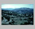
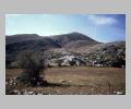
The mountainous region in the center of the Peloponnese is called Arcadia. The dominant feature of this region is the plain of Tripolis, a great plateau of fertile land. Apart from the Plain of Tripolis, Arcadia is ringed by great mountains: Mount Kylline ( 2376 m), Mount Erymanthos ( 2224 m), and Mount Khelmos ( 2355 m). Drained by the Alpheus River and its tributaries, which run westward to the sea, Arcadia's small valleys have a hard climate. High in elevation and remote from the sea, the continental climate of the central Peloponnese supports cattle, sheep, horses, asses and pigs, and hardy crops of wheat and barley.History
From the second millennium B.C. to the Roman imperial period Arcadia was occupied by Arcadians. Because their possession of the territory was never contested, not even by the Dorians moving into the Peloponnese after the twelfth century, the Arcadians not only maintained control of their region, but also managed to hold on to their own dialect. The dialect resembles old Cypriote, and preserves elements of Mycenaean Greek. In the fifth century B.C. and again in c. 250 B.C. the Arcadians formed themselves into a league.Sites
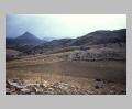
Mantinea, lying 15 km north of Tripolis above the Plain of Tripolis, was formed by the amalgamation of five villages at about 500 B.C.. It was one of the most important Arcadian city-states and the rival of Tegea. Much of the city's history revolves around this rivalry, which was based on disputes over water. The walls of Mantinea are believed to be contemporary with those of Messene (c. 370 B.C.), and may have been built by the same Theban architects. Since the circuit of the walls is almost entirely elliptical with a perimeter of nearly 4.1 km, they are considered one of the finest examples of Greek fortifications. Within the walls are the remains of a Roman theater, an agora, and a council house. Tegea, located 8 km southeast of Tripolis, was Mantinea's rival in antiquity. It was the largest city in the Plain of Tripolis, and waged an unsuccessful war with Sparta in the sixth century B.C.. One of the most famous sanctuaries in Greece, the Temple of Athena Alea, lies in Tegea. In 395 B.C. the Archaic Temple burnt down and was replaced by a Doric Temple built by Skopas of Paros. The new temple had 6 columns by 14 columns and an internal colonnade of Corinthian half-columns with Ionic columns located above. It is unknown whether or not the pedimental sculpture, now in Athens, was done by Skopas, but it depicts the Kalydonian Boar Hunt on the east and the Fight of Telephos and Achilleus on the banks of the Kaikos in Mysia on the west. The celebrated Temple of Apollo Epikourios at Bassae is situated at a height of 1130 m. on the slopes of remote Mount Lykaion (1398 m). Mt Lykaion was the center of a cult of Zeus, the rituals of which included rain-making, human sacrifices, and athletic games. Asea is a small village located in the dreary Asean plain, near the springs that form the source of the Alpheus river. The village was populated from the Neolithic to the Middle Helladic period, and was then reoccupied in Hellenistic times. Further along the Alpheus river, perched on an isolated hill at the northwest corner of the plain of Megalopolis, is the small Medieval town of Karitaina, famous as the stronghold of the Greek Revolutionary War Chieftain, Theodoros Kolokotronis. The Plain of Megalopolis in western Arcadia is ringed by mountains, but enjoys a much more temperate climate than the Plain of Tripolis, for it is pleasantly wooded and watered by the Alpheus River. When the Pan-Arcadian League formed after the battle of Leuktra in 371 B.C., Arcadia lacked a capital, so the great city of Megalopolis was built and was populated by inhabitants from other cities in Arcadia. The ancient city was surrounded by walls with a total extent of almost 9 km, and included a fourth century B.C. theater which could accommodate 50,000 spectators, a meeting hall, and the Thersileion named after its donor. On the other side of the river Elisson, there was a large sanctuary of Zeus Soter. Beyond this lay the agora, bounded by a stoa of Phillip II of Macedon. Curtis Runnels- history: Paus. 8.1.4-Paus. 8.6.3
- formerly called Pelasgia: Paus. 8.4.1
- boundaries: Paus. 6.21.3, 4
- highest mountain of: Paus. 8.17.1
- kings: Paus. 8.1.4-Paus. 8.6.1
- cities of A. abandoned to found Megalopolis: Paus. 8.27.3-7
- part of A. conquered by Orestes: Paus. 2.18.5
- Oresteum in: Apollod. E.6.27
- Lycurgus in: Apollod. 1.8.2
- Atalanta in: Apollod. 1.8.2
- the hearth of Telephus in: Apollod. 1.8.5
- ravaged by a bull: Apollod. 2.1.1
- traversed by the mad daughters of Proetus: Apollod. 2.2.1
- Stymphalus in: Apollod. 2.5.5
- the Cretan bull roams over: Apollod. 2.5.6
- Herakles in: Apollod. 2.7.3
- Arcas brought up in: Apollod. 3.8.2
- Cyllene in: Apollod. 3.10.1
- booty of cattle driven from: Apollod. 3.11.2
- Mantinea in: Apollod. E.7.37
- its relations with Sparta: Hdt. 1.66
- a Pelasgian people: Hdt. 1.146
- preservation of thc cult of Demeter: Hdt. 2.171
- Cleomenes in Arcadia: Hdt. 6.74
- Arcadian settlements in Cyprus: Hdt. 7.90
- Arcadians at Thermopylae: Hdt. 7.202
- Arcadian deserters to Xerxes: Hdt. 8.26
- Arcadians in the Greek army on the Isthmus: Hdt. 8.72
 mountains and terraced hillside |
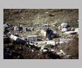
 column bases (mentioned by Pausanias) |
 Sacred Peak from Pan Sanctuary near basin |
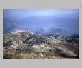
 view from Sacred Peak to south |
 Ancient spring just east of Hagno Spring |
 view to Bassae from Sacred Peak |
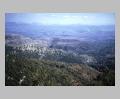
 view to east from Sacred Peak, with Karitsena on right |
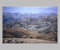
 Megalopolitan Plain from west |
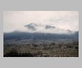 snow-capped peak from east |