

The Atlas is an interactive tool for investigating the geography of the Greek world and the surrounding Mediterranean region. The Atlas has graphic drawings, digital elevation models, satellite images, and three-dimensional topography views. Various functions in the Atlas allow you to locate and plot sites, compute distances between sites, identify sites within a region, examine elevation and drainage, and zoom in and out to see maps of different scales. As a geographic reference, the Atlas can be used in traditional ways, but its content and design encourage more complex and interactive uses.
"Projection" refers to the system used to translate locations on a (nearly) spherical earth into the plane of a map. The large scale longitude-latitude (lon-lat) map uses a Plate Carree projection. The other maps use the Universal Transverse Mercator (UTM) projection system.
"Coordinate system" refers to the system by which points on the current map are located. In Perseus, all geographic data are recorded in longitude and latitude coordinates, expressed in degrees (minutes, seconds) east of Greenwich, England and north of the Equator. The large scale lon-lat map works directly with these coordinates in a Plate Carree projection. The other maps use the UTM coordinate system expressed in integers in a UTM projection.
"Graphic Map Index" refers to the black and white line drawings that serve as pointers and gateways to detailed maps. Typically, a map index shows a line drawing of the Greek world overlaid with numerous rectangles. The rectangles are active areas that, when clicked, open the respective detailed map in the selected scale and theme (defined below).
"Scale" refers to the meters-per-pixel ratio of the maps. Depending on the current map, the scale may be 1300, 1000, 500, 250, 125, or 60 meters per pixel. (A pixel is the unit of measure for a computer monitor.)
"Theme" refers to the type of map selected, such as a color topography map. The map themes are defined below.
"Detailed maps" are the color maps and the black and white topography maps.
Outline maps: Large and small scale black and white line drawings show an outline of the coastline of the Greek world from Sicily and Magna Graecia to Asia Minor.
Black and white topography: This black and white line drawing shows elevation, and resembles a standard paper topographic map, with contour lines showing 1000 foot intervals in elevation.
Satellite images: These maps show a conventional representation in false-color of satellite data and cover the Greek mainland. The three bands of satellite data are shown in red, green, and blue.
Color elevation maps with rivers: These maps have been created from digital information on land elevation. A range of colors, from yellow to dark brown, is used to describe elevation. These maps show streams and lakes overlaid on topography.
To see a map, choose an item from one of the pop-up tiles on the Graphic Map Index. (The procedure is described in detail in section 7.2.) To return to the Index, click Graphic index of maps on the Atlas Tools Palette. To move to an adjacent topography map to the north, south, east, or west, click the directional arrows around the magnifying glass icon. To move to the next highest scale map in a theme, click once in one of the map's quadrants. To move to the next lowest scale map in a theme, click on the minus sign inside the magnifying glass icon.
When you are viewing a topography map, you can plot sites, plot sites within a region, and compute distances between points.
A summary of features found in the color maps is shown in the table below:
| Map Theme | Scales (meters per pixel) | Plot Sites | Plot Sites in Region | Compute Distances |
| False-color Infrared | 500, 250, 125, 60 | Yes | No | Yes |
| Color Topography & hydrography | 500, 250, 125 | Yes | Yes | Yes |


Figure 7.1 Coverages in Perseus 2.0 of the Greek world by the various theme sources.
The false-color infrared maps are based on five regions in mainland Greece:
Epirus (Albania/Illyria)
NW Greece (Acarnania, Phocis, Aetolia, etc.)
SE Greece (Attica, Boeotia, Euboea, Thessaly, etc.)
Peloponnese, including Attica
Macedonia/Thrace
The key used to read elevations from the color elevation maps is available by clicking Show DEM Key on the Atlas Tools Palette, lower right. A small floating window with the color key and elevation scale appears. Hide the window by clicking the close button on the Key.
The color topography maps are available in three scales, 500, 250 and 125 meters per pixel.
The DCW offers worldwide coverage of a variety of themes represented as vectors in the Vector Product Format. For the Perseus Atlas, the most important themes are topography and hydrography. The published accuracy of the DCW is roughly 1:1 million, but according to the developers of the DCW, the accuracy will be substantially better in many parts of the world.
The Landsat MSS sensors measure electromagnetic radiation at four different points in the spectrum: 0.5-0.6 micrometers (blue); 0.6-0.7 mm (green); 0.7-0.8 mm (infrared); 0.8-1.1 mm (infrared). Because different materials reflect and absorb radiation in characteristic ways, these data provide evidence of land cover.
The Atlas includes a database of approximately 1900 sites, based on maps published by the Greek Statistical Service, and on printed gazetteers. The Greek maps can be used reliably to within 30 seconds of longitude or latitude. (At 39 degrees of latitude, very near the center of our core area, 30 seconds of longitude represents about 720 meters on the ground.)
The Graphic Map Indexes are gateways to detailed maps; they are analogous to the map keys found in traditional print atlases (figure 7.1). The detailed maps - color elevation, satellite image and black and white contour maps - come in up to four scales. You choose which scale you want from the Graphic Map Index (see below).
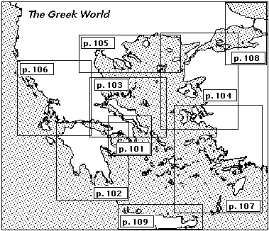
Figure 7.2 Map Key from a print atlas showing pages containing detailed maps.
The following examples are arranged to show first how to display the various map themes, then how to use the specialized map tools.
> Enter the Perseus Atlas environment.
From the Gateway, click the Atlas icon. Or from anywhere in Perseus, choose Atlas from the Links menu. Your point of entry into the Atlas is the Small outline map of the Greek world (figure 7.3).

Figure 7.3 Small Outline Map of the Greek World with Atlas Tools Palette, Scrolling Window, and Navigator Palette.
> Go to the Large outline map of the Greek world.
On the Atlas Tools Palette a magnifying glass, with plus and minus signs in the lens. To bring up the Large outline map of the Greek world, click the plus sign on the magnifying glass icon. You can toggle from Small to Large outline maps by clicking the plus and minus signs.
> Go to the Graphic Map Indexes.
From either the Small or Large outline map of the Greek world, click the button Graphic Index of Maps on the Atlas Tools Palette. An outline map appears with active rectangles, or tiles, overlaid (figure 7.4). The title field of the Atlas Tools Palette now reads Map Index.Note that as you move the mouse over the tiles they become highlighted.

Figure 7.4 Index of Maps with tile pop-up menu.
Move the mouse to the tile over the Attic peninsula (middle row, third from left). Hold the mouse down to bring up a pop-up menu. To see a detailed map, choose one of the pop-up menu items. The items available are Color Elevation Map with Rivers, Satellite Image and Black-and-white Contour Map. The interpretation of the detailed maps is explained below.
You can toggle between Satellite Image maps and Color Elevation maps by clicking the button on the Atlas Tools Palette. This action will preserve sites plotted on one of the color maps. However, it is necessary to return to the Graphic Map Index to go to a Black-and-whicte Contour map. Any plotted sites will be lost unless you first save them by clicking the Search Saver icon on the Navigator Palette. To replot the sites, choose Plot Sites in Search Saver from the Atlas menu. To return to the Graphic Map Index, click the button Graphic Index of Maps the Atlas Tools Palette (figure 7.5).

Figure 7.5 Toggle buttons on Atlas Tools Palette.
The scale bar shows the distance taken up by one hundred pixels of the monitor's screen. The distance represented by the scale is shown above it in kilometers and changes depending on the scale of the map.
The Atlas Tools Palette has an information field at the top that reports the theme of the map you are viewing, and below it a button to go directly to the Graphic Map Index.
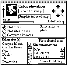
Figure 7.6 Atlas Tools Palette
The small magnifying glass surrounded by directional arrows is a navigation tool for moving among maps in the current theme. To change the scale of a map within a theme, click the plus sign (+) in the magnifying glass and you will zoom in to the next larger scale of the current map, if one is available. Click the minus sign (-) and you will zoom out to the next smaller scale of the current map, if one is available.
The detailed maps come in four scales: 500 meters per pixel, 250 meters per pixel, 125 meters per pixel and 60 meters per pixel. A pixel is a dot on the monitor of your computer. Since monitors vary from workstation to workstation, the representation of a geographical distance will also vary. However, you can readily get a sense of distance in the Atlas from the kilometer scale on the Atlas Tools Palette; its length is always 100 pixels, and the equivalent of 100 pixels in kilometers is displayed above the scale for each map.
Not every theme is available in each of the four scales. Satellite images are the only theme coming in the 60 meter/pixel resolution.
> See the four map scales available from the Graphic Map Index.
Enter the Graphic Map Index. There will be 15 tiles imposed upon regions covered by detailed maps. By default the scale displayed is the smallest, 500 meters per pixel, shown on the title bar (and on Atlas Tools Palette when the detailed map is displayed). The figure 260 km which you see currently displayed on the Atlas Tools Palette is the scale for the entire outline map.
Increase the scale by clicking the plus sign of the magnifying glass icon on the Atlas Tools Palette once. There will now be 56 tiles imposed upon regions covered by detailed maps. Each tile represents a detailed map at a scale of 250 meters per pixel.
Note that each of the former tiles is now subdivided into four tiles, with the exception of the tile over the upper Bosphoros (250 meter/pixel resolution is not available for that region).
Increase the scale to 125, then 60 meters per pixel by clicking on the plus sign of the magnifying glass icon. Note that the number of tiles on the Graphic Map Index again increases by a factor of four.
You can decrease the scale back to 125, 250 and 500 meters/pixel by clicking on the minus sign on the magnifying glass.
> See detailed maps in the four available scales. This example will use the Satellite image theme and zoom in on the Isthmus of Corinth.
Not all themes are available for each scale. The pop-up menu for each tile of the Graphic Map Index displays the themes available.
From the Graphic Map index at 500 meters/pixel scale, move the mouse to the tile over the Corinthiad (second row from top, third tile from left). Choose Satellite image from the pop-up menu. The satellite image will appear. The Isthmus of Corinth is the neck of land in the lower left quadrant connecting the Attic peninsula above with the Peloponnesus below.
To zoom in to the 250 meters/pixel scale, click the + sign on the magnifying glass icon on the Atlas Tools Palette. The cursor will now change to a magnifying glass. Now move the cursor over the Isthmus of Corinth and click it. The 250 meter/pixel satellite image will appear, with the Isthmus of Corinth in the lower right quadrant.
Zoom in to 125 meters/pixel by clicking the Isthmus; click the Isthmus again to reach the 60 meters/pixel map.
You can decrease the scale by clicking on the minus sign in the magnifying glass on the Atlas Tools Palette.
> Use the directional arrows on the Atlas Tools Palette to go to adjacent maps in the same theme.
Four arrows at 90 degree intervals surround the magnifying glass. These directional arrows, when clicked, move you to an adjacent map in the current scale (north, south, east, and west, respectively, for up, down, right, left). By using the directional arrows, you can skip the step of returning to the index to see an adjacent map.
The Show tools/Hide tools toggle switch alternately shows and hides three additional map tools, Plot Sites, Plot Sites in Area and Compute Distances. These tools appear in the interface as round buttons. When the map tools are showing, they are attached to the lower part of the Atlas Tools Palette.
> Click the Show tools toggle on the Atlas Tools Palette.
The Palette will expand to show the three buttons that operate the tools (figure 7.6).
> Plot the site of Delphi.
Make sure that the Atlas Tools Palette is toggled to Show Tools, and click the button Plot Sites.
The scroll bar at the right side of the Select Sites list provides a quick way to move through the list. (Remember that you can drag the scroll indicator up or down to move quickly in a list, rather than moving line by line.)
Click Delphi in the Select Site list, then click the button Plot selected sites. The site is marked with a dot; the site name may be dragged to another location on the map. You may need to drag the Atlas Tools Palette out of the way in order to see the plotted sites.
If you want to plot a number of sites -
- shift-click (click while holding down the shift key) to select a continuous range of sites.
- command-click (click while holding down the command key) to select a discontinuous range of sites.
When your selection is ready, click the button Plot selected sites.
The limit on the number of sites that may be displayed at one time is fifty.
The site coordinates appear in the scrolling field on the right and are given either in lon-lat degrees or UTM (explained in Atlas Settings, below).
> Define an area in Thrace for the Atlas to plot sites.
If you have been following the previous example, first clear old sites from the map by choosing Clear plotted sites on this map from the Atlas menu. Please be sure that the Atlas Tools Palette is toggled to Show Tools.
Click the button Plot sites in Area.
Three changes now take place in the Atlas Tools Palette: the scrolling field lower left becomes Sites in This Area; a new array of buttons appears lower right; and a message appears to the right of the radio buttons prompting you to click the button Define Area (figure 7.7).

Figure 7.7 Atlas Tools Palette showing changes accompanying Plot sites in area.
For this exercise, a sparsely populated region was chosen because on a small scale map, the plotted sites tend to get overcrowded. For best results, therefore, use the Plot sites in area feature on a larger scale map, and be careful not to choose too big or densely populated an area, because the maximum number of sites that the Atlas can plot is fifty.
Select approximately the area shown in figure 7.8.

Figure 7.8 Thrace with area selected.

Figure 7.9 Sites in Thraceward area.
KNOWN BUG: You cannot scroll down the Sites in area field, though the Atlas sites will plot them all.
> Compute the distance of the paraplous from Iapygeum to Syracuse, via Kroton, Locri and Rhegion.
From the Small outline map, plot the sites Iapygeum, Kroton, Locri, Rhegion and Syracuse according to the instructions above (figure 7.10).

Figure 7.10 Small outline map with sites plotted.
Three changes now take place in the Atlas Tools Palette: the scrolling field lower left becomes Travel log; a new array of buttons appears lower right; and a message appears to the right of the buttons prompting you to click the button Start route (figure 7.11).

Figure 7.11 Atlas Tools Palette showing changes accompanying Compute distances.
Click Start Route. The first point you click on the map will be the starting point. Click on the site of Iapygeum; it is now marked with an X.
Click again on the sight of Kroton, and the new leg will be connected with a straight line. Repeat for each site along the journey, making a dog-leg around the toe of Italy, until you are ready to end the route.
A running total with distance of each leg of the journey is kept in the field middle right.
When you have reached Syracuse, click the button Stop Route to end the trip. The total distance, 441 km., is computed for each trip in the Travel Log field, left (figure 7.12).

Figure 7.12 Paraplous from Iapygeum to Syracuse, with total distance computed.
> Save the results in your Travel Log to a Perseus Notebook page by clicking the button Save Routes to NB. Please read about Notebooks in chapter 10.3.
NOTE: If the distance computation feature is enabled, you cannot interrupt it to choose a map from a map index or plot sites from the site list.

Figure 7.13 Atlas menu.
There are four Map display options. The Show site names box is turned on (X-ed) by default, and instructs Perseus to display the name of the selected site. To make the site names disappear, click the Show site names box off. A dot will remain indicating the location of the site.

Figure 7.14 Atlas Settings options.
Click the Coordinates in longitude-latitude button to display site coordinates in degrees of latitude and longitude in the Site Information field on the Atlas Tools Palette. Alternately, click the Coordinates in UTMs button to display the site location in Universal Transverse Mercator coordinates.
There are two Map actions options. With the Zoom when map clicked box selected, you can zoom in on a map by clicking it.
The Always replot sites feature saves sites you have plotted while you to go to another stack in Perseus. The sites will not be saved upon quitting Perseus, however. Note also that this option will slow Perseus down.
Figure 7.15 shows the results of an inquiry for Phaleron. Select a theme at the right to go to that map.

Figure 7.15 Map Index (By Site).
To show the site names for a plotted region, choose the option Show Site Names When Plotting from the Atlas Settings.
> Plot the Mint locations for coins in Perseus from the Archaic period.
Get a list of Mint locations by making a Browser search (the Browser is described thoroughly in chapter 5.1). In the Browser, click the button Coins and choose the Search topic Period from the pop-up menu, top center. The pop-up menu now reads Period is ... Further refine your search by clicking Archaic. Set the left column of results to Mint (figure 7.16) Put your results into the Search Saver by clicking its icon on the Navigator Palette.

Figure 7.16 Browser serarch for coins of the Archaic period by mint.
If you need the scroll window to move around the graphic index or other black and white map, choose Scroll from the Go menu, or press Command-e. Press Command-e again to make the scroll window disappear. More detailed instructions for using the scroll window are presented in chapter 4.1.3.
The Small outline map is the default selection when you open the Atlas. Plotting sites on it is a fast way to locate sites in their geographical context.
When you are viewing the Small and Large outline maps, you can plot sites, plot sites within a region within a region which you define, and compute distances between points.
The black and white topography maps cover 15 regions of roughly 200 by 300
kilometers each:
Campania
Apulia
Bruttium (Calabria)
Sicily
Epirus (Albania/Illyria)
NW Greece (Acarnania, Phocis, Aetolia, etc.)
SE Greece (Attica, Boeotia, Euboea, Thessaly, etc.)
Peloponnese, including Attica
Cyclades
Macedonia/Thrace
Marmara Sea
Troad
Ionia/Lydia
Caria/Lycia
Crete
This same division of regions is also used for the color maps.
The Black and White Contour Maps are available from Graphic Map Index only when it is set at the 260 km. scale. To see a topography map, choose Black and White Contour Maps from one of the pop-up tiles on the Graphic Map Index. To return to the Index, click Graphic index of maps on the Atlas Tools Navigator. To move to an adjacent topography map to the north, south, east, or west, click the directional arrows around the magnifying glass icon.
When you are viewing a topography map, you can plot sites, plot sites within a region, and compute distances between points.
Every Macintosh with 5 MB RAM alloted to the Perseus Player can run the basic Atlas, meaning the color/black and white Atlas features, though it is preferable to have at least 8 MB RAM. The Computing Distances feature uses memory quickly, and users with less than 3 MB RAM who try to compute distances will get an error message, "Not enough memory to use the Painting Tools." (Consult chapter 2, "Setup," for a more detailed description of hardware and software requirements and memory issues.)
Black and white outline maps are part of a HyperCard stack. Color maps are drawn on the screen in a separate window. To achieve efficiency in memory and speed, leave the color window open only for as long as you are using color views in the Atlas, because the current color image will be replaced by your next selection. You can click another window to bring that window to the foreground, leaving the color map in the background. When you are finished with the Atlas, you must close the color map window by clicking the close box in the upper left corner. To avoid memory shortages, however, close all color windows when you no longer need them.