Via
(
ὁδός). A road. The earliest roads in Greece were the
sacred ways, which led to the most important religious centres, where national festivals were
celebrated, such festivals also serving the purpose of public markets or fairs. In general,
the Greeks set a high value on well-levelled roads, which made travelling easy; but, in the
best days of Greece, only unpaved roads were known, paved roads being of comparatively late
origin.
The finest work in ancient road-making was that done by the Romans, who, mainly for military
purposes, connected Rome with her newly acquired provinces by means of high-roads. They laid
out their roads as far as possible in straight lines. The nature of the ground was almost
entirely disregarded; where mountains intervened they were broken through, and interposing
streams and valleys were spanned with bridges and viaducts.
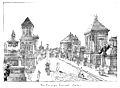
The first Roman high-road, which, even in its present condition, is worthy of admiration,
was the Via Appia, so called after the censor Appius
 |
|
Via Appia, near Ariccia. (Canina.)
|
Claudius, who constructed it. It was made in B.C. 312 to join Rome to Capua, and was
afterwards continued as far as Brundisium. This “queen of roads,”
regina viarum (
Stat. Silv. ii. 2,
12), was a stone causeway, constructed, according to the nature of the country, with
an embankment either beneath or beside it, and was of such a width that two broad wagons could
easily pass each other. The surface was paved with polygonal blocks of hard stone, generally
basalt, fitted closely together, and so laid down that the middle of the road was at a higher
level than the sides, to
 |
|
Pavement of Via Appia. (Piranesi.)
|
allow the rain-water to run off. According to a subsequent method, the Roman roads
first received a foundation of rubble or
breccia, on which rested a
layer of flat stones eight inches thick; above this was an equally thick layer of stones set
in lime, which was covered by another layer of rubble about three inches deep. Above the
rubble was laid down the pavement proper, consisting of either hard stone (
silex) or else irregular blocks of basaltic lava.
In the time of the emperor Hadrian, the cost of constructing such a road amounted to $4500
per Roman mile (about 4/5 English mile). From the end of the second century B.C. posts set up
at a distance of 1000 paces from each other served to measure distances. See Miliarium.
The making and maintenance of the roads in Italy were provided for at the expense of the
aerarium, or State treasury. During the republican age the roads were
under the supervision of the censors. From the time of Augustus they were under imperial
officials entitled
curatores viarum. In the provinces, in general, the
cost of the military roads, and indeed of all public works, was defrayed out of the provincial
taxes. In the imperial provinces soldiers were also frequently employed in constructing roads.
In a few cases toll was levied by special imperial permission. The following list of the great
Roman roads that issued directly from the capital will be convenient for reference:
I. The Via Appia, the Great South Road. It was in perfect repair
when Procopius wrote, long after the devastating inroads of the northern barbariaus; and even
to this day the cuttings through hills and masses of solid rock, the filling up of hollows,
the bridging of ravines, the substructions to lessen the rapidity of steep descents, and the
embankments over swamps, demonstrate the vast sums and the prodigious labour that must have
been lavished on its construction. It issued from the Porta Capena, and, passing through
Aricia, Tres Tabernae, Appii Forum, Tarracina, Fundi, Formiae, Minturnae, Sinuessa, and
Casilinum, terminated at Capua, but was eventually extended through Calatia and Caudium to
Beneventum, and finally from thence through Venusia, Tarentum, and Uria, to Brundisium.
The ramifications of the Via Appia most worthy of notice are:
(
a) The Via Setīna, which connected
it with Setia.
(
b) The Via Domitiāna struck off at
Sinuessa, and, keeping close to the shore, passed through Liternum, Cumae, Puteoli, Neapolis,
Herculaneum, Oplonti, Pompeii, and Stabiae to Surrentum, making the complete circuit of the
Bay of Naples.
(
c) The Via Campāna or
Consulāris, from Capua to Cumae, sending
off a branch to Puteoli, and another through Atella to Neapolis.
(
d) The Via Aquillia began at Capua, and
ran south through Nola and Nuceria to Salernum; from thence, after sending off a branch to
Paestum, it took a wide sweep inland through Eburi and the region of the Mons Alburnus up the
valley of the Tanager; it then struck south through the very heart of Lucania and Bruttium,
and, passing Nerulum, Interamnia, and Consentia, returned to the sea at Vibo, and thence
through Medma to Rhegium. This road sent off a branch near the sources of the Tanager, which
ran down to the sea at Blanda or the Laus Sinus, and then continued along the whole line of
the Bruttian coast through Laus and Terina to Vibo, where it joined the main stem.
(
e) The Via Egnatia began at Beneventum,
struck north through the country of the Hirpini to Equus Tuticus, entered Apulia at Aecae,
and, passing through Herdonia, Canusium, and Rubi, reached the Adriatic at Barium, and
followed the coast through Egnatia to Brundisium.
(
f) The Via Traiāna began at
Venusia and ran in a nearly straight line across Lucania to Heraclea on the Sinus Tarentinus;
thence following, southward, the line of the east coast, it passed through Thurii, Crotona,
and Scyllacium, and completed the circuit of Bruttium by meeting the Via Aquillia at Rhegium.
(
g) A Via Minucia is mentioned by Cicero,
and a Via Numicia by Horace, both of which seem to have passed
through Samnium from north to south, connecting the Valerian and Aquillian, and cutting the
Appian and Latin Ways. Their course is unknown. Some believe them to be one and the same.
II. The Via Latīna, another great line leading to
Beneventum, but keeping a course farther inland than the Via Appia. Soon after leaving the
city, it sent off a short branch (Via Tusculāna) to
Tusculum, and, passing through Compitum Anagninum, Ferentium, Frusino, Fregellae, Fabrateria,
Aquinum, Casinum, Venafrum, Teanum, Allifae, and Telesia, joined the Via Appia at Beneventum.
A cross-road, called the Via Hadriāna, running from
Minturnae through Suessa Aurunca to Teanum, connected the Via Appia with the Via Latina.
III. From the Porta Esquilina issued the Via Labicāna,
which, passing Labicum, fell into the Via Latina at the station ad Bivium, thirty miles from
Rome.
IV. The Via Praenestīna, originally the Via Gabīna, issued from the same gate with the former.
Passing through Gabii and Praenesté, it joined the Via Latina just below Anagnia.
V. Passing over the Via Collatīna as of little
importance, we find the Via Tiburtīna, which issued from
the Porta Tiburtina, and, proceeding northeast to Tibur, a distance of about twenty miles, was
continued from thence, in the same direction, under the name of the Via
Valeria, and, traversing the country of the Sabines, passed through Carseoli and
Corfinium to Aternum on the Adriatic, thence to Adria, and so along the coast to Castrum
Truentinum, where it fell into the Via Salaria.
A branch of the Via Valeria led to Sublaqueum, and was called Via
Sublacensis. Another branch extended from Adria along the coast southward through the
country of Frentani to Larinum, being called, as some suppose, Via
Frentāna Apŭla.
VI. The Via Nomentāna, anciently Ficulnensis, ran from the Porta Collina, crossed the Anio to Nomentum, and, a little
beyond, fell into the Via Salaria at Eretum.
VII. The Via Salaria, also from the Porta Collina (passing Fidenae
and Crustumerium), ran north and east through Sabinum and Picenum to Reaté and
Asculum Picenum. At Castrum Truentinum it reached the coast, which it followed until it joined
the Via Flaminia at Ancona.
VIII. Next comes the Via Flaminia, the Great North Road, commenced
in the censorship of C. Flaminius, and carried ultimately to Ariminum. It issued from the
Porta Flaminia, and proceeded nearly north to Ocriculum and Narnia in Umbria. Here a branch
struck off, making a sweep to the east through Interamna and Speletium, and fell again into
the main trunk (which passed through Mevania) at Fulginia.
 |
|
The Via Appia Restored. (Falke.)
|
It continued through Fanum Flaminii and Nuceria, where it again
divided, one line running nearly straight to Fanum Fortunae on the Adriatic, while the other,
diverging to Ancona, continued from thence along the coast to Fanum Fortunae, where the two
branches, uniting, passed on to Ariminum through Pisaurum. From thence the Via Flaminia was
extended under the name of the Via Aemilia, and traversed the heart
of Cisalpine Gaul through Bononia, Mutina, Parma, Placentia (where it crossed the Po), to
Mediolanum. From this point branches were sent off through Bergomum, Brixia, Verona, Vicentia,
Patavium, and Aquileia to Tergesté on the east, and through Novaria, Vercelli,
Eporedia, and Augusta Praetoria to the Alpis Graia on the west, besides another branch in the
same direction through Ticinum and Industria to Augusta Taurinorum. Nor must we omit the Via Postumia, which struck from Verona right down across the Apennines
to Genoa, passing through Mantua and Cremona, crossing the Po at Placentia, and so through
Iria, Dertona, and Libarna, sending off a branch from Dertona to Asta.
Of the roads leading out of the Via Flaminia in the immediate vicinity of Rome, the most
important is the Via Cassia, which, diverging near the Pons Mulvius,
and passing not far from Veii, traversed Etruria through Baccanae, Sutrium, Vulsinii, Clusium,
Arretium, Florentia, Pistoria, and Luca, joining the Via Aurelia at Luna.
(
a) The Via Amerīna broke off from
the Via Cassia near Baccanae, and held north through Falerii, Tuder, and Perusia, reuniting
itself with the Via Cassia at Clusium.
(
b) Not far from the Pons Mulvius the Via
Clodia separated from the Via Cassia, and, proceeding to Sabaté on the Lacus
Sabatinus, there divided into two, the principal branch passing through central Etruria to
Rusellae, and thence due north to Florentia, the other passing through Tarquinii, and then
falling into the Via Aurelia.
(
c) Beyond Baccanae the Via
Cimīna branched off, crossing the Mons Ciminus, and rejoining the Via Cassia
near Fanum Voltumnae.
IX. The Via Aurelia, the Great Coast Road, issued originally
from the Porta Ianiculensis, and subsequently from the Porta Aurelia. It reached the coast at
Alsium, and followed the shore of the lower sea, along Etruria and Liguria, by Genua, as far
as Forum Iulii in Gaul. In the first instance it extended no farther than Pisa.
X. The Via Portuensis kept the right bank of the Tiber to Portus
Augusti.
XI. The Via Ostiensis originally passed through the Porta
Trigemina, afterwards through the Porta Ostiensis, and kept the left bank of the Tiber to
Ostia. From thence it was continued, under the name of Via
Severiāna, along the coast southward through Laurentum, Antium, and Circaei,
till it joined the Via Appia at Tarracina. The Via
Laurentīna, leading direct to Laurentum, seems to have branched off from the
Via Ostiensis at a short distance from Rome.
XII. Lastly, the Via Ardeatīna, from Rome to Ardea.
According to some, this branched off from the Via Appia.
Travelling on the public roads was facilitated by the establishment of
(a)
mutationes (
ἀλλαγαί) or posting-houses, where horses
were changed and vehicles were obtainable if required; and
(b) mansiones
(
καταλύσεις), stations, caravansaries, or resting-places,
where the journey could be conveniently broken. The towns and places where a halt on one
ground or the other could be made are frequently detailed in the Antonine Itinerary. See
Cursus Publicus;
Itineraria.
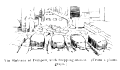
The following illustration of a part of the Via Stabiana at Pompeii shows four
stepping-stones.
 |
|
Via Stabiana at Pompeii, with Stepping-stones. (From a photograph.)
|
They are to be found in nearly every street in the town, whatever its breadth. The
narrower streets are practically blocked by single large stones in their centres; the broader
streets are crossed by rows, containing from two to five stones. Their shape is, generally, a
flat-topped oval: larger and smaller stones lying side by side. They measure, very commonly,
about three feet by eighteen inches, and have their longer axis parallel to the footway on either side of the street. The height of the footway ranges from twelve to
eighteen inches above the carriagè-way, and the particular height is, in most
cases, that of the stepping-stones also. The surface of the street being elliptical, the stone
on the centre stands slightly higher than those at the sides. Many streets are marked with
wheel-ruts, some of them deeply cut. They are found both in the interstices between the
steppingstones and elsewhere. The distance from rut to rut measures, as a rule, one yard,
which was, accordingly, the gauge of the ordinary vehicles. Some special consideration of
these stepping-stones is desirable.
Until the reign of Septimius Severus (A.D. 193- 211) riding and driving, both in Rome and in
the provincial towns, were closely restricted, and at times forbidden, by law (
C. I.
L. i. 206; Marquardt,
Privatleben, ii. 727-738). Claudius (A.D. 41-54)
forbade travellers to drive in carriages through provincial towns (Sueton.
Claud. c. 25). Marcus Aurelius (A.D. 161-180) again forbade riding and driving
in provincial towns. Under Severus carriages, in Rome at least, seem to have been more
commonly used (Dio Cass. lxiv. 4).
Thus, the street-traffic of the ordinary Roman provincial town seems to have resembled that
of the Tangier or Tetuan of to-day. Heavy burdens were carried on the backs of horses, mules,
or cattle. Walking was the rule, riding on horseback or in a litter was the exception, driving
almost unknown. Before the date of the edict of Claudius, and perhaps later, the law was
probably indulgent to towns such as Baiae and Pompeii. Thither came the
“carriage-company” of Rome to seek health and spend money. In the case of
Pompeii carriages and horses were, beyond a doubt, confined to certain streets. An extant
inscription shows that the station of the
cisiarii was not even within
the town walls. (See
Cisium.) Other streets were
always reserved for foot-passengers, and possibly for litters. Others, again, once open to all
traffic, and still bearing the marks of wheels, were afterwards closed to all but
foot-passengers by huge steppingstones or iron gratings.
The deep ruts already mentioned were the natural result of confining the traffic to a few
streets. None of these were broad enough to allow of any considerable variation of the track,
even had the fixed stepping-stones presented no additional difficulty. Moreover, there is
evidence that some of the existing pavements bore traffic for at least 120 years. It is not
surprising that even a small amount of wheeled traffic, unrelieved by the use of springs, and
acting on the same stones for so many years, should have left deep traces behind.
The reasons for the erection of very large stepping-stones were, no doubt, at once local and
practical. Pompeii occupies the summit and slopes of a small hill. Hence the lower streets,
according to the drainage level of the ground, received the rain-water and refuse of the
upper. In times of heavy rain the lower streets must have flowed like a torrent. No
sewerage-system could have at once mastered the downward rush of the water. Indeed a similar
sight may now be witnessed, during the winter rains, in the heavily paved streets of Florence,
where stepping-stones of the largest size would not be out of place. At Pompeii, where the lie
of the ground, together with the close-set stone surface and sides of the streets, provided a
ready-made watercourse, sidewalks of substantial height were absolutely necessary to
foot-passengers. The means of crossing from one sidewalk to another, in any weather, were
therefore naturally provided by stepping-stones of corresponding size.
See Bergier,
Histoire des Grands Chemins de l'Empire Romain (Brussels,
1736); Burn,
Rome and the Campagna (London, 1870); and
Middleton, Remains of Ancient Rome (1892).


