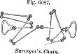
Sur-vey′or's-chain.
This chain, called
Gunter's, after the name of the person who adapted it, is 4 rods or 66 feet long, made of Nos. 6 to 9 wire, and has 100 links.
10 of these square chains are equal to an acre.
66 × 66 × 10 = 43,560 feet = 1 acre; or, counting by links, 100 × 100 × 10 = 100,000 square links = 1 acre.
 |
|
Surveyor's-chain. |
The chain is divided every 10 links by notched brass marks, so that the fractions may be readily distinguished.
Chains 100 feet long, divided into 1-foot links, are also used by civil engineers.
Other apparatus is used where extreme accuracy is required.
The
decempeda, or 10-foot pole, was the standard land-measure of
Rome.
The base line for the trigonometrical survey of
Great Britain was laid down by
General Roy on
Hounslow Heath, and is 5.2 miles long, nearly.
It was measured at first with pine rods; but as these were found to be affected by the hygrometrical changes of the atmosphere, it was again measured with glass tubes 20 feet in length, furnished with a peculiar apparatus for making the contacts.
In the subsequent measurement of the same line for the
Ordnance Survey, two steel chains of 100 feet in length, and made by
Ramsden, were employed.
One of these was kept as a measuring-chain; the other was kept for the purpose of comparing the measuring-chain with it before and after the operation.
In the act of measuring, the chain was laid in a trough supported on trestles, and was stretched with a weight of 56 pounds. The same apparatus was employed in measuring five other bases in different parts of the country, for the purpose of verifying the accuracy of the work.
For the measurement of the
Lough Foyle base in the survey of
Ireland, nearly 8 miles in length,
Colonel Colby employed a compensating apparatus formed of bars of different metals, so arranged that the distance between the two points viewed by compensation microscopes remains constant under all changes of temperature.
For account of measurements of degrees of latitude, see odometer.
“The method of triangulation in a great survey, by means of quadrilaterals, is purely American in its origin, having been first introduced by the late
Professor Bache.” —
Prof. Peirce.


