Break′wa-ter.
A structure or contrivance, as a mound, mole, wall, or sunken hulk, interposed to break the force of the waves and to protect an anchorage, harbor, or any object exposed to the waves.
Breakwaters for the purpose of protecting harbors are of very ancient origin.
The harbor of
Alexandria was protected by a stone mole called the Heptastadium, which joined the island of
Pharos and the main-land.
It had two passages through it, which were spanned by bridges.
Nebuchadnezzar built quays and breakwaters along the shores of the
Persian Gulf. —
Herodotus.
The harbor of
Rhodes and the Piraeus of
Athens were protected by moles, as were also those of Civita Vecehia,
Ostia,
Antium Misenus, and others among the Romans.
We are informed by
Josephus, that
Herod, desiring to form a port on the coast of
Syria, between
Joppa and
Dora, caused great stones, most of them 50 feet long by 10 wide and 9 deep, and some even larger, to be cast into the sea in 20 fathoms of water, with a view of forming a foundation for a mole or breakwater.
The
Romans constructed the moles or breakwaters of many of their harbors upon a double row of arches, so arranged that the openings of one set were opposite the piers of the other, by which means the force of the waves was thoroughly broken, while still permitting the passage of the current, thus greatly reducing the accumulation of deposits around the base of the structure, and consequent tendency towards filling up the harbor.
The piers of the new river-frontage of New York are to be constructed on pillars which allow free course to the water, being intended for wharfage, not wave-breakers.
The breakwater of
Cherbourg was commenced in 1784.
Its total length is 4,120 yards, consisting of two arms, respectively 2,441 and 1,679 yards long, forming an obtuse angle of 169° towards the sea. The average depth of water inclosed is 62 feet at high spring-tides, and the area sheltered is about
[
363]
1,927 acres, about one third of which has a depth exceeding 27 feet at low-water spring-tides.
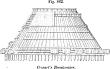 |
|
Cessart's breakwater. |
Cessart's plan for breakwaters at the latter part of the last century consisted of large truncated cones of timber floated by means of air-barrels lashed thereto, and towed to the spot.
These were 150 feet in diameter at the bottom, 64 at the top, and 70 feet high.
Ninety such cones were to be placed consecutively, to form a breakwater when sunk and filled in with stone.
The project was only partially carried out. The timbers were dislocated and the stones scattered.
The work was renewed by additions of stone till it reached the level of low-water spring-tides; upon these was laid a bed of hydraulic concrete five feet thick, and upon this was erected a solid wall of coursed ashlar masonry faced with granite.
The top of the sea-slope is covered with large loose blocks, and at the extremities of the wings it is farther protected by immense artificial blocks, weighing about 40 tons each, formed of rubble set in
hydraulic cement.
Fig. 883 (
a) shows a section of this work.
b is a section of the breakwater off
Plymouth, England, to protect the harbor, which is only open to the south.
It is situated upon the inner of three natural reefs of rock, which lay outside the harbor, and closes what was once a central passage, leaving open passages to the east and west.
The main body is placed perpendicularly to the S. S. E., and is 1,000 yards long.
Wings at each end form angles of 135°, and are each 350 yards in length.
A surface of 1,120 acres is protected.
It is 133 yards wide at bottom, 15 at top: a set-off 22 yards wide forms a foreshore on the sea side.
The upper portion is revetted with masonry laid in Roman cement on both faces and crown.
The hight of the latter is 2 feet above high-water spring-tides.
4,105,920 tons of stone were used in the construction.
Cost, $7,500,--000.
Delaware Breakwater is situated just inside of
Cape Henlopen, the southwestern point of land at the entrance of
Delaware Bay, and was intended to form a harbor of refuge during storms for vessels passing along the coast.
The work was commenced in 1829.
It consists of two parts, the breakwater proper and the ice-breaker.
The former is 1,203 yards long, extending in an E. S.E., and W. N.W. direction.
The ice-breaker is designed to protect the harbor from floating ice brought down by the
Delaware River, is 500 yards long, and lies in an E. by N. and W. by S. direction, having a passage of 350 yards between it and the breakwater, the prolongation of which would pass near the center of the ice-breaker.
The work protects from the more dangerous winds an area of about 420 acres, having a depth of 3 to 6 fathoms, leaving a passage of about 1,000 yards in length between the shore and its landward extremity.
 |
|
Breakwaters. |
The width of the structure is 175 feet at base and 30 feet at top, and it is composed of rough blocks of stone.
A transverse section is shown at
c,
Fig. 882. The inner slope has an angle of 45°, the outer slope has an inclination of 3 base to 1 of hight to a depth of about 19 feet below the highest spring-tides, and from thence to the bottom of 45°.
Breakwaters have also been constructed by the United States government at several lake-ports, particularly at
Buffalo and
Cleveland on
Lake Erie, and
Chicago on
Lake Michigan.
The covering pier or breakwater of Buffalo Harbor (
d,
Fig. 883) is built of stone, and cost about 8200,--000.
The illustration shows a cross-section.
It measures 1,452 feet in length.
The top of the pier on which the roadway is formed measures eighteen feet in breadth, and is elevated about five feet above the level of the water in the harbor.
On the side of the roadway which is exposed to the lake, a parapetwall, five feet in hight, extends along the whole length of the pier, from the top of which a talus wall, battering at the rate of one perpendicular to three horizontal, slopes towards the lake.
This sloping wall is formed of coursed pitching.
Its foundations are secured by a double row of strong sheetingpiles driven into the bed of the lake, and a mass of rubble
pierres perdues, resting on the toe of the slope.
The quay or inner side of the pier is perpendicular, and is sheathed with a row of sheeting-piles, driven at intervals of about five feet apart from center to center, to prevent the wall from being damaged by vessels coming alongside of it.
The harbor of the city of
Pernambuco, in Brazil, is defended by a natural breakwater, — a reef of hard coral just level with the sea, and extending for miles along the coast, parallel with the main-land and but a very short distance from it, leaving a narrow channel of sufficient depth to float vessels of considerable size between them.
[
364]
Here ships may ride in perfect safety, the water being as smooth as a mill-pond, while the sea is breaking furiously upon the reef, even at times casting its spray on the decks of vessels moored inside.


